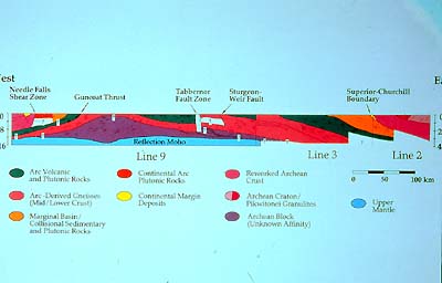
A geological cross-section showing the principal tectonostratigraphic
units of the Trans-Hudson Orogen. It is based on seismic reflection
profiles (whose locations, lines 2, 3 and 9, were shown in the previous
slide), as well as on geological information obtained at the surface
and from drill cores, and on potential field maps. The stippled
lines indicate in a schematic fashion the dip and frequency of seismic
reflections. |
LITHOPROBE's seismic cross sections show a THIRD
Archean craton to be present (purple blob above “Reflection
Moho”), over which the overlying rock layers were pushed and
shoved and now drape, to the west on its west side, to the east
on its east side. (See the schematic cross section shown on the
screen.) This discovery of a formerly unsuspected, additional Archean
remnant between the Superior and Hearne-Rae cratons, and within
the general THO domain, came as a complete surprise to the geoscientists.
Although hidden underground from direct view there are several "basement
windows" in the Glennie Domain which may belong to the same,
newly discovered craton.
This find in central Saskatchewan's underground also has a deep
crustal root, as is expressed in the local thickness of the crust,
whose base is defined by the (seismic) Mohorovicic discontinuity,
or "Moho" for short. (See the lowest unit in the schematic
cross section.) The question now is how far this third Archean block
extends to the north and south. Is it an ancient microcontinent,
does it connect somewhere? Diamond hunters are interested in this
find in that wherever the crust is thick and Archean, the potential
for diamonds is great. Kimberlite occurrences (the volcanic pipes
which are potential sites for diamonds) appear to be associated
with this Archean block.
We want to remember the assembly of THO, the map showing the tectonic
units, and the schematic cross section which crosses them to give
us a 3D image. This is because at the same time the THO came about
through continental collisions, the same happened over the area
which now underlies Alberta. It seems to have been a more or less
simultaneous (or coeval) series of events, a sort of double billing,
with two large mountain belts having been formed side by side, as
it were, separated only by the Hearne Province, which itself was
deformed and imbricated (different slices of it thrust on intermingled,
thereby forming a stack).
|
