Geologists wax enthusiastic about the Trans-Hudson
Orogen because it is one of Earth's great examples of a preserved
collisional belt. Perhaps, they cherish the orogen's very complexity,
an outcome of a colourful tectonic history, represented by rift
and strike-slip as well as compressional styles, juvenile oceanic
crust to remnants of an old Archean craton, and just about everything
else in between.
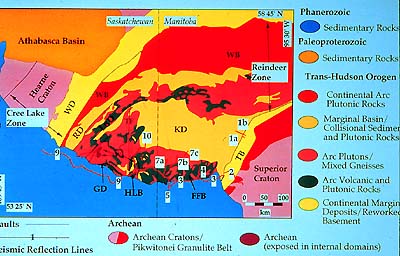
In Saskatchewan-Manitoba the Trans-Hudson orogenic belt is subdivided
into four major tectonic zones which our slide shows. We see a southeastern
foreland zone (yellow with TB and adjacent dark red), a large internal
zone of juvenile Proterozoic crust (includes FFB, KD, HLB, GD and
RD), an Andean-type magmatic arc batholith (red with WB), and a
northwest hinterland zone (yellow with WD).
The southeastern foreland zone is the narrow Churchill or Boundary
Zone, which includes the Thompson belt (in dark red and yellow).
The zone forms a dogleg going from southwest to east along the edge
of the Superior craton. Petrochemistry of volcanic rocks in this
zone suggests that the volcanics and the associated metasediments
(= sediments altered or metamorphosed by heat and pressure), formed
in a rift (where the crust partially split).
The internal Reindeer Zone extends over to the other side of the
THO (to the opposite fold belt marked in yellow). The Reindeer Zone
is a 400-km-wide collage of Early Proterozic (1.9 to 1.8 Ga) island-arc
volcanics, plutons (underground magma intrusions), volcanogenic
(derived from eroded volcanoes) sediments, and younger molasse (=
detritus from mountain ranges) derived from newly formed mountains.
These Early Proterozoic island-arc terranes were severely deformed
by the vice action of the collisions, and include imbricated sheets
of rock formations thrust upon and into each other. Remember that
between them the Superior and Hearne-Rae Provinces crunched the
whole works together.
Geochronological analysis using isotope measurements has shown
the Wathaman-Chipewyan batholith (red with WB) to have been emplaced
at about 1,855 Ma. (A "batholith" is a large-volume magmatic
intrusion into overlying rocks, and comprises many individual plutons.)
It sits between the arc terrane of the Reindeer zone to the southeast
and reworked continental rocks previously eroded from the Archean
Hearne-Rae craton to the northwest.
The fourth zone is the hinterland of the sequence, the Wollaston
Fold belt (yellow with WD). This zone also is highly deformed and
metamorphosed, and complexly interfolded with Archean basement rocks.
Many disciplines of the earth sciences contribute to the research
sorting out this complex overall picture of past tectonic events.
Comparisons of this old orogen are made with, say, the western part
of the modern Himalayas where comparable oceanic rocks are sandwiched
between two converging continents (India northward against Eurasia).
Let's cut a vertical slice through this map, crossing its tectonic
trends.
|