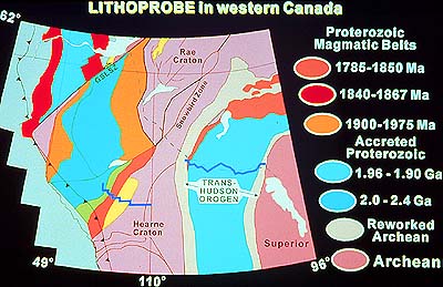
We recognize the old Archean cratons, the Superior,
Rae and Hearne in pink. Pay attention to the Snowbird Tectonic Zone
which we again will encounter in maps of the Alberta Basement. The
Snowbird Tectonic Zone (STZ) is a very prominent, very important,
once very active, now very old tectonic feature along which truly
gigantic tectonic battles were fought between contending continental
plates.
Follow this line southwest, into the Alberta Basement transect area,
where the STZ abruptly ends at the eastern edge of the Rocky Mountains,
cut by a mighty thrust fault (line with teeth) which we can see
today from the air and on the ground.
The Cordillera represents the youngest addition to our continent,
one which, really, still is ongoing. Remember when we stood at the
Pacific coast, at Long Beach on Vancouver Island, looking west to
where, under the ocean, a Pacific oceanic plate is moving (or subducting)
under our continent? It is moving now, while we are looking at the
map.
Anyway, the STZ can be followed from the Rocky Mountain foothills
northeast, and then east, all the way to Hudson Bay ...... Earth
scientists can pick this tectonic zone out in many outcrops on the
ground, on aeromagnetic and gravity maps, and, sometimes, on seismic
reflection lines which cross it.
We remember that this is a map from which we have stripped the
sedimentary cover where it exists today (in most of Alberta, say),
hiding the crystalline underground and the old tectonic units from
our eyes. The only orogens (mountain belts) which still are visible
to the eye today as a picture similar to that when they were formed
are those which have not yet been fully eroded or covered by later
sediments, those which still are mountains, like the Appalachians
in the east and the Rocky Mountains in the west.
How do we know that the basement below the sediment cover is there?
Good question! That's what the LITHOPROBE project is all about,
that is to see not only where rocks are exposed but also far below
them, down to their roots. On this map, for instance, we can follow
the tectonic and rock units from the Canadian Shield into the areas
where the Shield becomes covered with sediments. One way we do this
is by using an aeromagnetic map such as this one.
|