| Seismic surveys are an important component of LITHOPROBE research.
These experiments involve generating seismic energy by compressing
and/or shearing the earth at one point, and receiving the energy
at a second point. The path the waves travel through the earth
is dependent upon rock properties. Sophisticated data processing
techniques allow geologic structures to be imaged and rock properties
to be constrained. When this information is combined with other
geological, geophysical and geochemical data, interpretations
of crustal structure and evolution can be made.
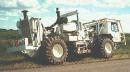 LITHOPROBE seismic
reflection surveys use vibroseis
trucks as the seismic energy source.
When a truck reaches a specified source point, an on-board
hydraulic system depresses a central
plunger against the ground raising the 20,000 kg truck into
the air. Then, the hydraulic system vibrates the mass of the
truck over a precisely controlled frequency band (e.g., 10
to 56 Hz). Typically, four vibroseis trucks are operated synchronously
and the resulting data permits mapping crustal structures to
depths up to 50 km. The energy produced by these trucks is
recorded by an array of 240 (or more) geophones. Click for
more information on the seismic reflection method. LITHOPROBE seismic
reflection surveys use vibroseis
trucks as the seismic energy source.
When a truck reaches a specified source point, an on-board
hydraulic system depresses a central
plunger against the ground raising the 20,000 kg truck into
the air. Then, the hydraulic system vibrates the mass of the
truck over a precisely controlled frequency band (e.g., 10
to 56 Hz). Typically, four vibroseis trucks are operated synchronously
and the resulting data permits mapping crustal structures to
depths up to 50 km. The energy produced by these trucks is
recorded by an array of 240 (or more) geophones. Click for
more information on the seismic reflection method.
In the summer of 1995 as part of the Alberta Basement Transect,
an experiment was carried out to image not only crustal structure,
but structure in the upper mantle. The upper mantle is normally
a very poorly reflective region, suggesting that the mantle
rocks exhibit gradual contrasts in properties. However, conventional
crustal reflection surveys may not generate enough energy to
clearly detect subtle structures at upper mantle depths. Therefore,
to explore the upper mantle using standard techniques, twelve
20,000 kg vibrators were operated simultaneously (see picture
above).
Stay tuned to find out what was discovered beneath Southern
Alberta.
|