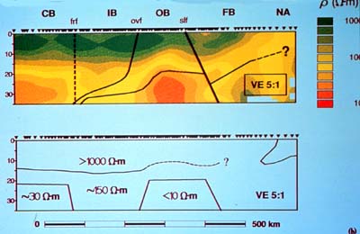
This slide shows a regional resistivity (inverse
of conductivity) structure across southern British Columbia. The
units (in colours) of resistivity (r) are Wm. The arrowheads on
top of both sections indicate the position of the recording stations.
Note the vertical exaggeration is 5:1.
Scientists like checking up on their own work, preferably through
methods different from what has led them to their conclusions. For
instance, a chemist can establish through a chemical analysis that
the nugget he is handed consists of pure gold; but so can a physicist
by precisely measuring the nugget's volume and specific gravity
(the latter is the Archimedes principle we have learned about in
physics).
So, LITHOPROBE scientists who probe Earth's crust by employing
seismic (sound) waves and their reflection by different layers in
the crust use entirely different types of measurements to check
up on the seismic results. Gravity data are one way of doing this,
but these data rely on physical properties of the measured rock
(namely their densities) which also influence the rocks' seismic
responses.
Thus, geophysicists employ electromagnetic (EM) studies which reveal
subsurface structure in terms of a physical property, electrical
conductivity (or its inverse electrical resistivity), that is independent
of the other physical properties on which seismic and gravity measurements
rely.
Most of us have experienced electrical conductivity through an
electric shock, which is even more effective when we are unfortunate
enough to touch live wires with wet hands or a wet towel. Don't
try it, but believe me that it would work even better if the fluid
we have on our hands was salty. And if your worried buddy would
grab you by the hand that same moment, both of you would be conductive.
(It's advisable to turn the electricity off instead.) So, this is
how effective a force electric conductivity can be.
Electrical conductivity also is extremely sensitive to composition,
texture and fluid content within the rocks of the lithosphere and
thus provides another facet to integrated programs of crustal study.
In the continental crust, saline water in interconnected pores
and fractures is probably the most widespread cause of high electrical
conductivity. Alternate explanations involve the presence of graphite
or partial melt (molten rock), both of which are conductive. So,
high electrical conductivity alerts us to the possible presence
of fluids in the measured rock, or else graphite or melt. All of
this can be measured without having to dig a hole down to where
these electric responses are coming from.
Now, we already know that fluids within the continental crust are
vitally important, both in the mode of deformation of rocks and
in the genesis of ore deposits. The roles of volatile fluids in
the crust are discussed further in the subsection on Geochemistry.
In tectonically active regions, such as the Cordillera west of
the Rocky Mountains, other fluids, silicate partial melts, can cause
high electrical conductivities in the lower crust and upper mantle.
Rocks are composed of a number of mineral constituents which melt
over a range of temperatures. At a temperature within the melting
range, a partial melt may occupy cavities in the solid matrix of
the remaining minerals. As most silicate melts are excellent conductors,
a rock with a few percent of melt in interconnected cavities may
have high bulk conductivity. Thus EM geophysics may detect and map
partial melt in anomalously hot regions, such as those along the
Southern Cordillera Transect.
By the way, where does the electricity (whose impact we are measuring
here) come from? Glad you were going to ask. Also, let's cut corners
here, because you touched a difficult spot of science, where not
all there is to know is known yet. One reasonable explanation is
that the core of the earth, together with heat-generated convection
streams, rotate at speeds different to surrounding matter, thus
friction and electricity is induced, i.e. the dynamo effect. This,
in turn, is thought responsible for the electromagnetic field, or
magnetosphere, surrounding Earth. This magnetosphere, in turn, induces
electricity into the crust (from above). Since the surrounding magnetosphere
is subject to solar winds (protons from the sun), it shows variations.
These, in turn, provide all sorts of opportunities one can measure.
At any rate, where does the electricity come from? From Earth's
core dynamo, via the induced magnetosphere around Earth, which,
in turn, induces electricity into the crust. Within the crust, different
rocks and various fluid contents provide differing conductivities;
thus these differences can be measured. Pretty neat, I 'd say!
LITHOPROBE's electromagnetic studies generally comprise two types
of field surveys. Broadband tensor magnetotelluric (MT) soundings,
which rely on the effects of Earth's magnetospheric field, is one.
The other measures varying the effects of controlled, man-induced
electricity, which is the electro-magnetic (EM) method.
The former, magnetotelluric soundings (MT) are recorded with station
spacings of a few to tens of kilometers, and provide regional coverage
along the transects. These make use of natural time-varying EM fields
due to electric currents in the magnetosphere and ionosphere. These
fields are recorded over a wide range of frequencies enabling derivation
of conductivity structure from near the surface to mantle depths.
Recently, the GSC has developed extremely "long-period recording
magnetotelluric instruments" (LIMS), collecting data which
can provide conductivity information to depths in excess of 500
km! Thus, these can provide a “probe” into the sub-crustal
lithosphere and upper mantle of Earth.
When specific geological targets or other features have been identified,
high-resolution, controlled-source, electromagnetic methods are
employed to better delineate conductivity anomalies in the upper
crust.
Reconnaissance surveys and some special projects are carried out
by university and GSC scientists who have the necessary equipment.
Analysis of the complex data sets and presentation of results are
greatly enhanced by the recent availability of powerful computer
workstations with interactive and colour capabilities.
LITHOPROBE results and those from other countries have shown that
in the study of a continental crust in which fluids are important,
electromagnetic geophysics, reflection and R/WAR seismology are
much more powerful together than each is alone.
Heat Flow and Geothermal Studies
We already have discussed that Earth itself is our biggest nuclear
power station. The Earth's internal heat drives tectonic processes
and is ultimately responsible for the formation of mineral deposits
and the maturation of hydrocarbons in sedimentary basins. Thus any
studies of these processes must include the contributions, past
and present, of heat flow. Within the Earth, heat is produced by
the decay of naturally occurring radioactive elements and by mantle
cooling. Many tectonic processes generate local heat perturbations,
as evidenced directly by volcanoes and hot springs.
Heat flow measurements are commonly made in drillholes on land or
at sea with special probes into the soft sediments of the sea bottom
and also in drillholes. While some holes are drilled specifically
for heat flow measurements, many heat flow values are determined
from previously drilled "boreholes of opportunity". To
calculate heat flow values, temperature gradients and thermal conductivities
of the rocks in which the temperature gradients are being measured
must also be determined. Using measured heat production values and
other thermodynamic properties, thermal modeling can provide estimates
of temperatures today and in the past.
Temperature-dependent rheological properties (that is how stiff
the rocks are; over long periods of time, such as those we deal
with in geology, rocks can actually flow) control zones of strength
and weakness in the crust and thus depths at which tectonic motions
could take place. In sedimentary basins such as that east of the
Rocky Mountains, movement of water in the rocks greatly affects
measured heat flow. Geothermal studies of the fluid migrations are
of great value because they detect water speeds of a few centimeters
per year which can be discerned in no other way. Both university
and government scientists have the necessary facilities and expertise
and are actively participating in thermal studies relevant to LITHOPROBE.
|