 A
poster and associated web pages provide a cross-section of
the earth's structure beneath southwestern
Canada. The 100-km deep cross-section crosses the Juan de Fuca
ridge where new oceanic crust is formed west of Vancouver Island
and continues east across the continent. The profile traverses
the earthquake-prone subduction zone beneath Victoria and Vancouver
and extends across the Rocky Mountains to the foothills of
Alberta. In addition, the poster describes the techniques that
geoscientists use to probe the earth's structure and history. A
poster and associated web pages provide a cross-section of
the earth's structure beneath southwestern
Canada. The 100-km deep cross-section crosses the Juan de Fuca
ridge where new oceanic crust is formed west of Vancouver Island
and continues east across the continent. The profile traverses
the earthquake-prone subduction zone beneath Victoria and Vancouver
and extends across the Rocky Mountains to the foothills of
Alberta. In addition, the poster describes the techniques that
geoscientists use to probe the earth's structure and history.
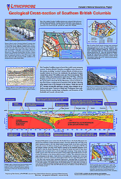
The history of southwestern Canada is extremely complex and
includes major episodes of mountain-building, addition of islands
and continental fragments, volcanism, and faulting. This dramatic
evolution of the "solid" earth continues today. The
poster provides a current snapshot of the earth's structure
beneath southern British Columbia, extending 100 kilometers
below the surface. The cross-section starts to the west of
Vancouver Island, crossing the Juan de Fuca ridge where new
oceanic crust is formed. Continuing east, the profile traverses
the earthquake-prone subduction zone beneath Victoria and Vancouver,
crosses the active volcanic belt, and extends across the fold
and thrust belts of the Rocky Mountains to the foothills of
Alberta. In addition, the poster describes some of the techniques
that geoscientists use to probe the earth's structure and history.
View Poster Panels
The eight panels of the poster can be viewed individually by
clicking here.
High Resolution
A higher resolution version of the complete poster can be viewed
(or downloaded) by clicking
here. Caution: 1.3 Mb gif file (120dpi).
|
