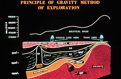
Remember how geoscientists employ gravity measurements
to create maps which can say a lot about what lies below the surface?
The intensity of the gravity field at the surface of the Earth is
affected by the shape and rotation of the Earth (latitude), distance
from the centre of the Earth (latitude and elevation) and the density
variations of the rocks beneath the surface. Measuring the spatial
(i.e. from one place to the next) variation of gravity, plus knowing
the Earth’s shape and the instrument location, to take care
of shape and distance factors, thus provides important information
which can be used to calculate density distributions in the lithosphere.
Interpretations of these distributions carried out in conjunction
with seismic refraction and reflection interpretations gives us
a powerful investigative tool because a well-established relationship
between the density and seismic velocity of rocks provides a mutual
constraint (i.e. check) on the modeling.
|