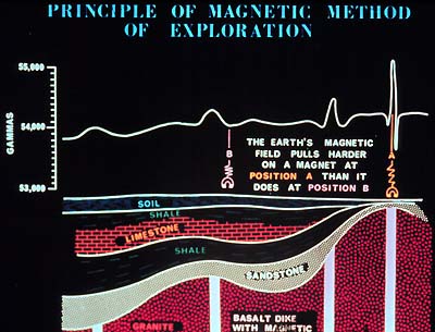
The magnetic field measured at or above the
Earth's surface is dependent upon the magnetization and iron content
of the rocks making up the crust. Magnetic anomaly data, derived
after subtraction of time variations and broad-scale regional fields,
can be a powerful interpretive tool for establishing the geometry
and nature of subsurface rock formations. Aeromagnetic surveys on
land and marine magnetic surveys at sea have contributed data to
the National Magnetic Data Base compiled and maintained by the GSC.
Much, but not all, of Canada is covered by such surveys. Through
a GSC-LITHOPROBE/industry consortium, a large gap in the publicly
available data base in central and southern Alberta has been filled
as part of the Alberta Basement Transect scientific program.
Aeromagnetic surveys have been a primary exploration tool for much
of Canada and are extremely important in providing maps from which
unexposed geology can be deduced. On the color-coded aeromagnetic
maps, the geologic texture of any region is immediately evident
and major discontinuities are readily identified.
|