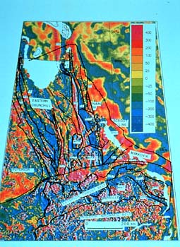
When igneous or sedimentary rocks are formed,
the minerals with magnetic properties contained in them align themselves
parallel to the force of Earth's magnetic field. Intensities of
magnetic minerals, and their alignment, will vary from place to
place. With the help of computers we can display the different magnetic
intensities as colors on a rather striking map, which shows up the
different tectonic elements.
On the left of the slide we see the northeastern corner of the Superior
Province, and on the upper right the southwestern extent of the
Nain Province. These two Archean cratons crunched between them all
of the tectonic terranes which are aligned along the roughly north-northwest
trending fault lines in the centre and upper portion of the map
-- the eastern extension of the Trans-Hudson Orogen. The great Grenville
Orogen cuts across it all with a mighty push from the south, wiping
out the pre-existing tectonic signatures with its roughly east-west
trending features.
|