LITHOPROBE's intensive lithospheric study of
the western North American Cordillera, from the eastern edge of
the Rocky Mountains to the offshore west of Vancouver Island, was
the first encompassing, multidisciplinary investigation of such
a mountain system. Not surprisingly then, the Canadian portion of
the Cordillera has been the birthplace of many new concepts in global
tectonics.
An 1,100-km long cross section of these findings is shown in the
brochure folder. By the way, it is true to scale, i.e. no vertical
exaggeration was used. You are looking at a scientific first here,
at a summation of tectonic and structural insights which is benefiting
research into other mountain systems, on this and other continents,
and with regard to features formed recently or farther back in the
geological past.
For example, geological and geophysical studies in southwestern
Canada, particularly over the past 25 years, have established that
the lithosphere of the Cordillera has evolved through episodes of
rifting, sea-floor spreading, and plate separation, followed by
subduction, ocean-basin closing, and plate accretion. Of course,
you do remember all of these concepts, don't you? We just discussed
rifting and sea-floor spreading when we heard about the Iapetus
and Atlantic Oceans. Plate separation is a bit hazy, in that this
can involve more than mere separation by rifting, but also movement
of one plate with respect to the other along strike (of the separating
feature, generally a giant fault, such as the Queen Charlotte Fault
just west of the Queen Charlotte Islands; this is Canada’s
equivalent of the San Andreas fault). Subduction, like that of the
Juan de Fuca oceanic plate under Vancouver Island, we have got down
pat. Ocean-basin closing is a clear case, and plate accretion we
also have discussed, but will hear more about now.
The concept of accretion of far-travelled crustal blocks (terranes)
that comprise plate fragments, island arcs, or microcontinents,
was developed partly in the Canadian Cordillera. It now is used
to interpret geological relationships observed in many other orogens
of the world.
Again, let's not be frightened by words -- all they do is describe
things and happenings. When you put two mud pies together you accrete
them side by side. Depending on how hard you press them together,
and what happens to the twosome thereafter, they may stick together.
Island arcs? Think of the Aleutians, Indonesia or the Philippines;
or, in a different setting altogether, the Hawaiian islands. You
might say it's a loose, but still descriptive, term. What else have
we got here? Oh, yeah, there are microcontinents; well, small continental
plates, which we have discussed many times by now.
So, let's stir up these things and mix a tectonic cocktail of the
real world.
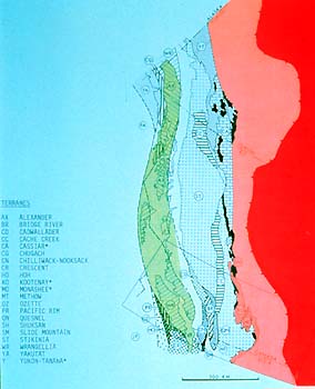
Well, let's not opine too early here. It so is clearer than mud.
Consider, how these various patterns and colours (for the different
accreted terranes) do provide some degree of clarity. Geologists
and geophysicists generally start out with a dog's breakfast, sorting
things out by rock type, position, age, and so forth. In any case,
it's a descriptive map of what, seemingly, was a less than orderly
collage. Nature can be that way. On the other hand, consider how
orderly the sorting of your beach sand is, for instance! And this
collage also follows or indicates certain patterns; one just has
to know the why and how.
At any rate, take in the big picture, the colours and borders.
The big, dark red is the North American craton onto which (from
the west) the Rocky Mountains, in light red, were shoved by plate
tectonics. The borderline between the two designates the eastern
edge of the thrust fault plane on which the outer mountains were
carried onto the undisturbed craton. (And there are more such fault
planes farther back into and throughout the Rockies, making the
mountains form a stack of imbricated layers of rocks of different
types and ages.)
Then, we have white and light green colours. The white is on land
-- comprising the Intermontane composite terrane, the green consists
of islands and part of the western edge of British Columbia, which
is the Insular composite terrane. Clear as mud pies! Which refers
to the adjective "composite." All this word is meant to
say (here) is that these terranes comprise accreted material which
originated from near the west coast as well as from, presumably,
much farther away, where they formed on oceanic crust and whence
they were carried to the west coast.
So, let's define our map some more. The old Precambrian craton
is a clear case, so are the Rocky Mountains. Next to the west, the
uncoloured portion is, like the green belt, a mix of accreted terranes.
Curious scientists (who, in private, must be good at working Rube's
cube) have found out which accreted terranes were formed near the
west coast and marked them with a star (sorry, only on the legend,
to keep the map demuddified).
Our continent gained, and grew westward, by the accretion of new
terranes from near and far. There also was erosion and sedimentation
of course, just as it is happening now, and there were volcanoes.
The sediments also were added on as they reached the shore lines
(having been carried their mostly by rivers) and were dumped in
between whatever else was coming along as accreted terranes. Look
at the Fraser River's sedimentary fan when you fly over it next
time.
Researchers have figured out that since the Precambrian, the continent
grew westward by about 500 km, adding a day's drive for land lubbers
on their annual summer run to the ocean beaches. That addition works
out to a little less than 1 km for each one million years. But this
growth was not a dull, even-measured affair; it came in spurts and
periods. Much of the accretion took place during the interval 180
Ma to 58 Ma, or from the Jurassic to the Lower Tertiary, which belong
to the Mesozoic age (which comprises the Triassic, Jurassic, and
Tertiary, from oldest to youngest). We remember that this accretion,
and the subduction of a moving oceanic plate which underlies these
accretions, is continuing today.
Indeed, an important.htmlect of the Cordillera is that it is evolving
in much the same way today as it has for the last 200 Ma, thereby
providing an "actualistic model" (has a nice ring to it,
`like, where it's at' in the vernacular), anyway, providing an ongoing
model that can be integrated directly with earlier processes and
deformation.
LITHOPROBE's area of study or "transect" is marked on
the map by the box. This Southern Cordillera Transect gives us an
outstanding opportunity to look into the processes that were responsible
for westward growth, the processes that influenced the crust and
lithosphere prior to the accretion of terranes, and the processes
that were important in the subsequent modification of the Cordillera.
This modification involves another, or several, subsequent process(es),
such as lithospheric "extension" as observed in the Intermontane
composite terranes (about which more later).
The main tenor of LITHOPROBE's study of the Southern Cordillera
is to carefully integrate all the various applicable earth-science
disciplines and methods so that they all can advance, and check
upon, each other. This integration, LITHOPROBE's multidisciplinary
approach, includes seismic reflection, seismic refraction, and electromagnetic
images of deep crustal and lithospheric structure. Hand in hand
with this subsurface approach goes the work by geologists at the
surface, understanding more about the geology and geochemistry of
near-surface rocks, including the paleomagnetism. Then there are
the gravity and magnetic fields which are measured over the region.
We’ll learn more about all of these shortly. All of this contributes
to our understanding of how the westward growth of the continent
took place, in which way and by what specific events. This knowledge,
in turn, then can be applied elsewhere.
|