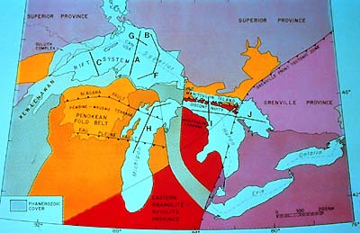
This area is a junction of several major tectonic
features. On the right we recognize the Grenville Province and the
Grenville Front Tectonic Zone, along which the Grenville Province
was thrust onto the Superior Province, cutting in the process across
other tectonic units then existing. Among these are the KRS and
the Penokean fold belt. Even more so than the Grenville Orogen,
the Penokean fold belt has been deeply eroded, due to its older
origin, 1,890 to 1,820 Ma, the 70-million-year period during which
this fold belt originated.
The Keweenawan Rift System dates back to an extensional period during
which the continent was split deeply to its very crustal roots,
but still stayed together, if just. The KRS formed during a 20-million-year
interval, 1,110 to 1,090 Ma, and is today an arcuate structure that
extends 2,000 km from Kansas in the south over Lake Superior and
northern Lake Michigan into Michigan. Only in the Lake Superior
region are Keweenawan rocks exposed.
And here is how this enormous scar in Earth's crust looks on a
seismic reflection profile. Before we switch slides have a look
at its location, line F on the Great Lakes map. After it we shall
see a model constructed from complementary geophysical information,
line A, which also crosses Lake Superior just west of line F.
|