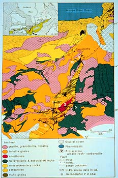
The KSZ is a block of lithosphere that at one
time resided 20 km below the surface. In one or two immense heaves
of the Earth, between 2,600 and 1,900 Ma, these rocks from the deep
were thrust 70 km eastward and up to the surface, where we can walk
on them today.
The map area is crossed by an ancient fault line, the Ivanhoe Lake
Fault Zone, which shows clearly on gravity and aeromagnetic maps.
The fault line runs from Lake Superior to James Bay. Along this
west-dipping fault plane the KSZ thrust carried highly altered rock
units from the deep onto less altered rocks of the Abitibi subprovince
east of it .
|