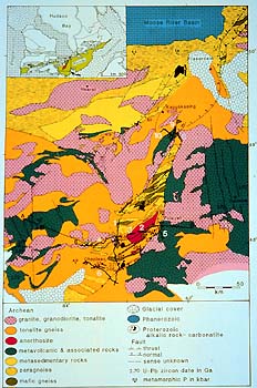
The inset in the map shows the location of the
map with respect to subprovinces of the Superior province. The KSZ
is shown by the magenta colour. We shall come back to this slide
in a minute. Line A-B-C-D is the location of a cross section which
is a typical multidisciplinary interpretation using seismic reflection,
seismic refraction, other geophysical, geochemical, geochronological,
and geological data. Here is the cross section.
|