The Superior craton shows some remarkable features.
It comprises a series of granite-greenstone "belts," each
100 to 200 km wide, which trend approximately east-west. (Granites
are formed when magma cools; greenstone belts are roughly linear
bodies of mostly volcanic rocks, whose metamorphosis caused their
greenish colour, with some plutonic rocks. They are typical for
Archean cratons.) Canada's rich mineral resources largely occur
in them. They are divided by a series of sedimentary subprovinces.
Their lithology (rock type), age and metamorphic grade (degree of
alteration by heat and pressure associated with deeper burial and/or
tectonic stresses) differ from one another. They are known as subprovinces
(of the Superior province). Four primary types of such belts have
been observed, and they have analogs in similar belts caused by
modern plate tectonics.
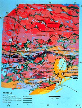
They include volcanic-plutonic terranes (greenstone-granite belts,
here coloured in greens and pinks) which resemble island arcs. We
all know what a volcano is. A pluton is a magmatic intrusion which,
unlike a volcano, did not break through to the surface. We still
need to know the meaning of "terrane." It describes a
distinct piece of crust, homogeneous in its tectonic style and makeup,
and separated by discontinuities (e.g. faults) from adjacent terranes
displaying different characteristics. Some plutonic complexes could
be slivers from continents.
Some belts consist primarily of just plutonic rocks, large tracts
of magma-derived rocks (shown in pink).
Yet another type found consists of metasedimentary (i.e. containing
sediments altered by metamorphism) belts (yellow colours) which
resemble accretionary prisms. (Originally, these prisms likely were
large bodies of sediment, perhaps residing on a subducting ocean
plate, which have been attached to the craton by tectonic forces.
This is the mechanism which currently is attaching new material
against the west coast of Vancouver Island.) The prisms were altered
by high temperatures and pressures due to being buried.
Then there are high-grade gneiss complexes (purple and grey shades).
(Gneisses are banded rocks formed under a high degree of regional
metamorphism, exerting strong pressure on the rocks.) Their high
degree of metamorphism probably signifies that they represent deeper
levels of the various other terranes found, meaning that what had
been above them was eroded.
There is a general age progression from north to south in the Superior
Province, from approximately 3,100 to 2,650 Ma, which has been interpreted
as resulting from the tectonic assembly of successively younger
arc terranes. One explanation is that the evolution of the Superior
province was dominated by a province-wide, southeast-facing, arcuate,
north-dipping subduction zone at approximately 2,730 Ma. After this
time, the evolution of the Superior craton was controlled by the
accretion of ocean crust and island arc fragments. The last collisions
occurred approximately from 2,690 to 2,680 Ma. For our purpose it's
enough to know that these were in the Late Archean.
We mentioned the importance of greenstone belts to our mining industry,
one of the resource pillars of the Canadian economy .
|