When LITHOPROBE's earth scientists check out
the covered Alberta Basement they use all the tricks of the earth-science
profession. We mentioned that they follow the exposed units in the
bare Canadian Shield as they dip under the sediments, also that
certain properties of the rocks underneath the surface can be measured
by remote means: the resistance to electric currents induced in
the earth by large sheet currents flowing in the earth’s magnetosphere
10s to 100s of kilometers above the surface, for instance; or the
different rock densities that perturb the gravity field; or variations
in the content of magnetic minerals in rocks that affect the magnetic
field, as well as other properties of the rocks below.
But the sedimentary cover itself, the sediments deposited in the
Western Canada Sedimentary Basin or WCSB, have many stories to tell.
First, there is the undeniable fact that the basement had to sink
to allow the basin to be formed. Also, from the exposed Shield to
the front formed by the Rocky Mountains, the basin progressively
becomes deeper, thus the rate of subsidence was faster closer to
the mountains than close to the Shield. Think of sediment layers
as wedges which are thin toward the Shield, and become progressively
thicker toward the mountains.
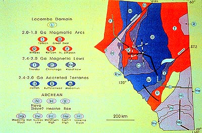
And doesn't the map of the tectonic elements we are looking at
give the sense that the AB really is quite a mosaic of different
tectonic units? And those are just the big units; within themselves
they also display differences.
To make a quite complex story short, different parts of the basement
have behaved differently over geological time. Quite possibly, they
still do. Those portions in the basement which sank less rapidly
than adjacent parts, or even rose, will have developed a thinner
sedimentary cover during their times of differential movement.
The WCSB has been poked into and even through by an immense number
of wells. Their records have been kept. Seismic reflection and refraction
surveys have provided many seismic cross sections which allow us
to correlate between these wells. [And now you know what geophysicists
and geologists in the oilpatch are doing for a living.]
We know the times of deposition of various sediment intervals from
fossils they contain, and from isotope geochronological methods.
So, by measuring the various sediment layers in the WCSB through
well bores and by correlating seismic reflection surveys, we can
tell when and where certain parts of the basin sank faster than
adjacent ones, or when the reverse may have happened. It means a
lot of work! Why do we go to all this trouble?
We are trying to establish this interaction between basement floor
and sedimentary cover to determine in which manner the basement
has exerted influence on the types and rates of sedimentation and/or
erosion at certain times. This goes beyond mere thickness differentials
and includes types of sediments deposited (i.e. sand or carbonates
or clay), and what happened to them later when formation fluids
circulated through the sediments.
Again, the question is did the basement exert an influence, and
how? Why, for instance, did reefs (often associated with porous
structures that trap oil and gas) grow in Devonian times along certain
lines and areas of the Alberta shelf? Why are there intervals with
good porosity in some and not in other areas, often side by side?
Such questions have immense implications for the oil and gas industry.
For instance, the flow of formation fluids, and their chemical makeup,
determine where oil and gas may migrate to, and where porosity may
have been opened up through recrystallization of the sediments or
else plugged by these processes. This explains why exploration-minded
oil and gas companies take such an interest in the LITHOPROBE project.
But, we now want to get at the basement itself. How did this mosaic
of different crustal units of varying ages and composition come
about, and when? The oldest tectonic units we see on the map are
shown in pink, and they are Archean in age. In the southeast are
parts of the Hearne and in the northeast of the Rae Provinces. In
the west lies what is called Nova here, but may be part of the Slave
Province (which lies farther to the north).
Next oldest are the dark blue units, what is called accreted terranes
here, units added on to what had been there before. Of similar,
Early Proterozoic age are the purplish magnetic lows, 2,400 to 2,000
Ma. And then come the hot orange terranes, including magmatic arcs
which form where plates collide and rupture. This was the time of
real tectonic action for the Alberta Basement, and also elsewhere
along the western Shield, 2,000 to 1,800 Ma.
In very general terms, the Hearne craton in the southeast collided
with the accreted terranes and the Slave Province (or portions thereof)
in the northwest, and, farther northward, the Rae Province. A later,
northeast directed movement pushed the Rae and Hearne Provinces
alongside each other.
And here we meet the mighty Snowbird Tectonic Zone (STZ) again,
along which the northwest shoulder of the Hearne and southeast side
of the Rae crunched alongside each other, eventually joining them.
Remember it from our discussion of the Trans-Hudson Orogen? The
THO was formed when the Rae-Hearne Province collided with the Superior
Province to the southeast. Now you know why the STZ is such a mighty
and persistent feature, being the fault line along which the Rae
and Hearne moved relative to each other.
When we move from the THO map southwest along the STZ, the STZ
eventually merges into the wider Thorsby Low (the purplish T area
on our map). In central Alberta the Hearne and Rae don't rub each
other, but left space between themselves. In fact, the Rae is gone
as it angles in a clockwise move into the more northerly parts of
the Hearne. Since we are at it, we might as well complete this complicated
discussion. To do this, perhaps, we should look at the larger North
American perspective once more. But before we switch slides, picture
the Rae in the northwest, the Superior in the southeast, and the
Hearne coming up between them. Hearne and Rae fuse along the STZ,
then both squeeze the Trans-Hudson Orogen toward the Superior Province.
Farther south, Rae to the northwest and Hearne did not fuse directly,
but left oceanic and other crust between them. Orogens formed in
THO, east of Rae-Hearne, as well as west of Hearne in Alberta. Part
of what pushed things in the northwest was the Slave craton. Somewhat
similar to what Rae did to Hearne in the north, the Slave moved
alongside the Rae in a northeasterly motion, eventually fusing with
the Rae. These wrenching movements took place along another enormous
fault zone, known as the Great Slave Lake Shear Zone (GSL on the
map), along which the northwest shoulder of the Rae and southeast
side of the Slave crunched alongside each other.
At the risk of offending the experts, we might recall the recent
California earthquakes — those which happened along the San
Andreas fault, also a wrench fault. The similarity lies in the fact
that the Pacific plate west of it is moving along the fault plane
northward in relation to the North American plate. One difference
with the STZ and the GSL shear zone is that along them continental
plates were rubbing shoulders along much of their extent, the Rae
and the Hearne, opening in the southwest, and Slave and Rae cratons,
with the latter shear movement also squeezing the Thelon Orogen
between them.
If we are really daring we can look at some schematic sketches
of our discussion:
|