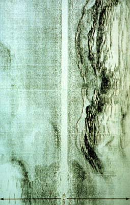
A marine side scan imaging system produced a sonar
image of the sea floor, which is comparable to an aerial photograph
of a land surface. This side scan was taken just at the position
where the Juan de Fuca Plate is plunging beneath North America.
This causes sediments of the ocean basin to be scraped off the
plate and thus attached to the continent.
The straight, blank strip crossing the middle of the image
is the northwest-directed track which the survey ship is
following. The scanner makes a 10-km wide image of the sea
floor (see the scale), but leaves out the blank area directly
below the ship.
The light grey image area with no features, seen below the
blank strip, shows the flat ocean bottom. Above the strip,
the darker grey areas depict the first rumpling and thrusting
of the sediments covering the ocean floor. As the heavier
Juan de Fuca Plate slides under the lighter North American
continent, the latter acts like a bulldozer pushing the sediments
resting on the ocean plate into hills and ridges which are
hundreds of meters high.
|