So, let's go to the biggest of Earth's oceans,
the Pacific. We start our journey into Earth's inner space at
a beach, to look out at the place where the LITHOPROBE project
got started a decade ago: Long Beach, at the mighty Pacific,
on Vancouver Island, where people holiday and watch whales.
Out to sea, just over the horizon, and on the sea floor below
the waves, the face of the Earth is being resculptured. How?
In a big way. Our continent is colliding with a part of
the Pacific Ocean, bulldozing its unstoppable path across
the ocean floor, and scraping off the ocean sediments to
slowly add to the westward growth of North America.
Big as our mightiest ocean is, it is shrinking slowly but
steadily, being squeezed by surrounding continental regions.
Thus, the west coast and its offshore are a good place to
study this gigantic happening, which only is the most recent
of several more such events which occurred earlier.
Indeed, it was here where Canada's LITHOPROBE Project, the
pioneering study of our continent's growth over geologic
time -- from small microcontinents to today's size -- had
its beginning.
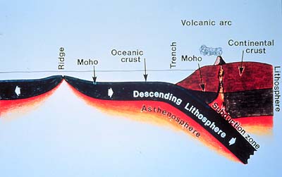
This schematic cartoon shows the outer layers of Earth's
crust. The solidified lithosphere is some 100 km thick.
The phenomenon which causes processes such as shown in this
schematic view of "subduction" of the "oceanic
plate" under the continent is popularly known as "continental
drift", but more correctly is called "plate tectonics."
These terms describe the constant shifting and jostling
among adjoining crustal plates, which are like pieces in
a mosaic which forms the hardened outer shell, the so-called
lithosphere, of our planet.
|