|
|
|
 |
| media > poster > |
| Geological Cross-section of Southern British
Columbia |
|
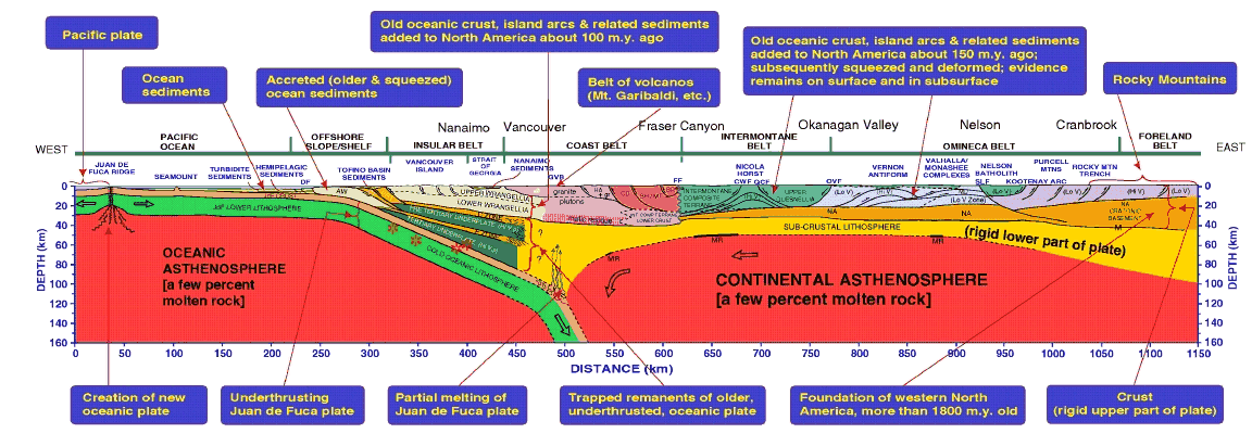 |
Interpreted lithospheric cross section from the
Pacific Ocean to the Rocky Mountains was derived from synthesis
of many geoscience studies. Old rocks (greater than 1800 Ma)
of the North American craton to the east extend
below younger rocks as far west as the Fraser Canyon. In a series
of collisions during the past 200Ma,
blocks of lithosphere 500 Ma old and younger collided with early
North America, pushing up the sediments
deposited on the old shelf to form the Rocky Mountains. In so
doing the blocks lost much of their lower
lithosphere (into the mantle below), with the upeer part remaining.
Today young (less than 20 Ma) oceanic crust
of the Juan de Fuca plate is being pushed under North America
at rates of about 50 mm/year as the
tectonic plates continue to collide. This subduction causes the
many earthquakes in the region.
Open arrows in the mantle show material flow of the Juan de Fuca
plate and of the continental asthenosphere
below the more rigid lithosphere above it. The open stars indicate
major earthquake hypocenters.
Abbreviation details: AW - accreted wedge; BR - Bridge River
terrane; CD - Cadwallader terrane;
CT - Crescent terrane; CWF - Coldwater fault; DF - deformation
front; FF - Fraser fault; gr - granites;
GVB - Garibaldi volcanic belt; HA - Harrison terrane; Hi V, p
- high velocity and density; Lo V - low velocity;
M - Moho; MD - Monashee decollement; MR - mantle reflector; MT
- Methow terrane;
NA - North American cratonic basement; OVF - Okanagan Valley
fault; PRT - Pacific Rim terrane;
QCF - Quilchena Creek fault; SH - Shuksan terrane; SLF - Slocan
Lake fault. |
| previous image |
next image |
|
