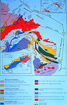
Let's take in the vibrant colours of the map
-- a better display than many dress ties would show. The first impression
one gets is the contrast between the lower and the upper parts of
the map. One sees not only different colours but also contrasting
orientations. Both are important. The colours refer to two things:
the types and the ages of the rock units they represent (see the
legend for this). The contrasting lineations, and the juxtaposition
of the variations in colours and directions, originated from the
collision of two large cratons. We remember the Grenville Orogen,
and how it cut across everything that had existed prior to being
thrust upon the pre-existing part of the Canadian Shield. That line
of fault thrusting is the one along the "Grenville Front",
along which the tectonic styles change so dramatically. One must
marvel at the geologists and other earth scientists who contributed
to this map. First one finds rocks of various types, then one describes
units of them, next places them into their proper structural setting
and orientation, and dates them, and then reads all of this as one
dynamic story. Note, for instance, how the (red-coloured) Groswater
terrane of the Grenville Province overrides two, much older terranes
(in purple) of the Makkovik Province. Or see the younger "post-collisional
granite plutons" which were intruded into the older rocks of
the Pinware terrane (laid bare for us to see by subsequent erosion).
At any rate, we get the drift of how much information is contained
in such a geological map, and how it takes more than just one discipline
to sort out the geological and tectonic situation.
|