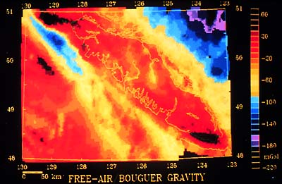
This slide shows the gravity map of S.W. British
Columbia and offshore region. Reds are high, yellows are intermediate,
and blues are low values. Can you see the outline of Vancouver Island?
Reconnaissance scale gravity data (station spacing on the order
of 6 to 8 km) is available for much of Canada through the National
Gravity Data Base maintained by the GSC. LITHOPROBE and other researchers
make extensive use of these data but they are often not appropriate
for detailed modeling. Thus LITHOPROBE now requires that the surveying
for seismic reflection lines also meet the necessary specifications
for gravity measurements, including absolute values determined from
GPS (Global Positioning System) measurements. With such surveying,
the acquisition of gravity data at station spacings of about 1 km
along the seismic lines is readily accomplished. This procedure
is now routinely carried out along LITHOPROBE reflection lines;
additional measurements are made when necessary and/or possible.
The gravity profile can then be interpreted with the reflection
data.
|