LITHOPROBE's scientific work is spearheaded by
the seismic reflection method because this is the geophysical technique
which produces the best images of boundaries between rock units
and of structures in the subsurface. It is the principal method
by which the petroleum industry explores for hydrocarbon-trapping
structures, that is oil and gas traps, in sedimentary basins. We
don't have the time to explain oil and gas exploration here, but
it, too, is a fascinating subject to get involved in.
Extension of the seismic reflection method to deep crustal studies
began in the 1960s and since the late 1970s reflection technology
has become the principal procedure for detailed studies of the deep
crust.
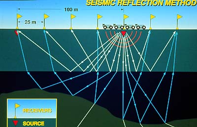
In its simplest form, the method is an echo technique based on
the same principles as sonar, i.e. bouncing sound waves off the
boundaries between different types of material: water and bottom
sediments for sonar, rock layers for crustal studies. The form of
presentation of the data is similar to that of a geological cross-section
and needs to be interpreted in terms of geology. Thus, geoscientists
must work together to provide the most complete interpretation;
this is the procedure followed in LITHOPROBE.
In its application, the seismic reflection method is highly complex,
involving a skilled acquisition crew with millions of dollars in
equipment, whether on land or at sea. As in the petroleum industry,
LITHOPROBE contracts the data acquisition to qualified industrial
contractors.
On land, LITHOPROBE has been using large truck-mounted mechanical
vibrators as sources (the "Vibroseis" method) because
they are logistically appropriate and environmentally safe for the
hard-rock areas in which we have worked; in one transect dynamite
has been used for the purpose of sub-crustal imaging and may be
used again, just as it sometimes is in industry. In all cases, federal
and provincial environmental and permitting regulations are strictly
followed.
In a typical regional survey at the present time, 480 groups of
9 to 12 geophone sensors per group are spaced at 25-m intervals
over a 12-km length to record ground vibrations caused by the Vibroseis
units. Sensor outputs are recorded on a truck-mounted computer system.
In addition, high-resolution surveys have been undertaken with
the participation and collaboration of industry and provincial government
agencies. These very detailed surveys aim at geological targets
(typically, the geological setting of ore bodies) in the uppermost
crust, i.e. the practical depth range for mining. To achieve the
desired greater detail, the 480 geophone groups are spaced at smaller
intervals (5 to 10 m) over only 2 to 5 km.
|