Back to building the really old, central parts
of Canada! Now, the old cratons get stitched together into a giant
quilt which will cover much of the continent.
When the old microcontinents collided, they pushed all that had
been between them together into collisional orogens, including newly
formed magmatic material (called "juvenile" rocks) and
accreted oceanic terranes, such as islands and groups of islands.
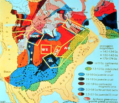
Take a look, for example, at the northwestern corner of North America.
The ancient Slave geological province is surrounded by three different
domains called Wopmay (in the west), Taltson (to the south), and
Thelon (on its east side). What are they?
The Wopmay terrane was already over the hump at about 2,400 to
2,000 Ma years when it was attached or "accreted" to the
Archean Slave protocraton between 1,900 and 1,700 Ma, forming the
Wopmay orogen. The Taltson terrane, on the other hand, is a magmatic
arc and relative youngster, whose plutons are 1,990 to 1,950 Ma.
The Thelon terrane also is an orogen, i.e. a mountain belt. It was
formed through an oblique collision between the Slave and Rae provinces.
This happened 1,970 to 1,920 Ma. It is the oldest orogen along which
Archean provinces were welded to each other.
The Superior Province is the largest component of the old continent,
a typical part of the Canadian Shield. The Superior province collided
with the Hearne and Rae Provinces to the north and northwest, which
also are of Archean age, at about 1,900 to 1,800 Ma.
This collision formed the Trans-Hudson Orogen. It extends from
the central United States across Manitoba and Saskatchewan. Then,
it turns east and northeast across the Hudson Bay to northern Quebec
and Ungava Bay, where the orogen is named New Quebec Orogen, completing
the long weld or stitch between the Superior, Hearne and Rae Archean
provinces.
To the northeast, the Nain Province includes rocks older than 3,800
Ma, which have been highly metamorphosed. By 2,600 Ma, Nain province
was complete, including its eastern extension into Greenland (and
beyond, to Europe). Remember how we can tell the ages of rock formations?
By looking at the earth scientists' reliable atomic clock —
by measuring the known rate of decay of radioactive isotopes.
Look again at our map, the "Tectonic elements of North America,"
this time at the northeast corner, where the northeastern edge of
the Superior Province juxtaposes the southwestern one of the Nain
Province. One would have been ill advised to stand between them,
because these two old cratons did what eventually they seem destined
to do, squeeze and crunch together what lies between them, compressing
wide regions, oceans, and so on, into relatively narrow mountain
belts or orogens.
In this case, it happened to include an eastern extension of the
Rae province which, we saw earlier, was involved in squeezing the
Trans-Hudson Orogen against the Superior province, creating in this
region the New Quebec Orogen, an easterly relation of the Trans-Hudson
Orogen.
On the other side of the Rae Province (also known as Eastern Churchill
Province here) the crunch from the Nain Province created the Torngat
Orogen. Perhaps, we should switch to a detailed sketch of this area.
|