LITHOPROBE's studies in the Southern Cordillera
have been taking place since 1984 when the project's Phase I provided
seismic and electromagnetic images of the oceanic Juan de Fuca plate
that is being subducted under Vancouver Island; and of overlying
fragments of the plates that have been added to the collage of accreted
lithospheric fragments in western Canada.
This slide incorporates later findings as well. But the first crustal
section from Phase I, across Vancouver Island, has been interpreted
to indicate that both tectonic erosion, wherein some of the older
lower crust is stripped off and recycled into the mantle, and subduction
underplating, wherein new and younger rocks are added to the continent
from below, are important processes that must be considered in global
models of continental evolution and growth.
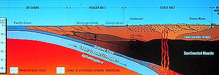
Continuing research has brought important insights, much of which
is summarized in the large cross section in our brochure folder,
representing 1,100 km of crustal profiling, from the Alberta plains
in the east to the Juan de Fuca ridge 200 km offshore in the Pacific
Ocean.
Some of the findings in a nutshell:
Microcontinents advancing from the west collided with our continent
and pushed thick sequences of rocks (which are up to 600 Ma old)
several hundreds of kilometers east onto the western margin of the
Alberta Basement (the North American craton), to form the Rocky
Mountains. So there was no giant collision between two giant continents
here, as we had seen in the creation of the Grenville Orogen. But
it shows just how effective these pushes and shoves can be, even
from microcontinents.
What was being shoved here had been deposited onto the western
extension of the Alberta Basement over long times, including all
the old and very old sedimentary sequences we find exposed in the
Rocky Mountains today. How far did the shove go? Very far, perhaps,
because there are indications that some of the fault planes accommodating
this movement sole out by the Fraser River. The cross section shows
the basement (mottled red) thinning and extending almost as far
as the Fraser Fault, and the overlying deformed and metamorphosed
sediments and other rocks (dark red) of pre-accretionary North America
stretching to the fault itself.
The collisions, and accretions of exotic Mesozoic terranes in central
British Columbia and the Coast Mountains, occurred 180 to 58 Ma
ago, as we already have heard.
Then, the convergence stopped. Now, remove the lateral pressure
on something as big and heavy as newly crunched-up mountains. Things
will slide back to find a new equilibrium. Thus, compression gave
way to tension, and large structures were a bit undone. Compressional
arches were "unroofed", i.e. lost part of their covers
as layers and blocks slid down on them.
|