And now, after having stitched together the Precambrian
Canadian Shield -- the Grenville Orogen had been its last addition,
we remember -- we have a choice. We now could discuss the theoretical
and practical.htmlects of the various disciplines and tools which
LITHOPROBE's earth scientists have trained on the deep secrets of
the continental plate; but this would just be for having a change
of topic, albeit not pace.
Instead, let’s think about how we started out, by looking
at a shrinking ocean with its surrounding earthquakes and volcanoes,
the Pacific ring of fire, and at the more peaceful shore at the
growing Atlantic ocean.
Super Continent Breaks, Joins, and Splits Again
Following completion of the Grenville Orogen about a billion years
ago, North America seems to have taken a bit of a breather. For
a period of almost 400 Ma, it wasn’t nearly as tectonically
active as it had been for the previous 400 Ma. That doesn’t
mean nothing was happening, only that what was going on was not
at the same grand scale as the events that we have been describing.
On the eastern part of the continent at around 600 Ma, a continental
rift was generated and an ocean, the predecessor of our Atlantic
Ocean, formed. After growing very large, it began to shrink due
to the action of other tectonic forces, and was eventually closed.
Some time later another rift opened up and the present Atlantic
Ocean was born. We’ll consider this in more detail shortly
but let’s remind ourselves of where we have gotten to.
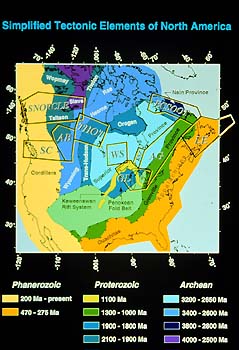
By now, these outlines of the major tectonic provinces of the continent
must look familiar to us. Look again at the outline of the Grenville
Orogen, or what's left of it after erosion has ground Earth's mightiest
mountain chain down by thousands of meters. At any rate, this is
the outline of the roots of the former system as earth scientists
can describe it to us now. Actually, even this outline isn't the
full extent Grenville had been, because, as we already have heard,
Grenville itself or Grenville with some additions of which we are
not aware, was split.
Imagine behind it, to its east, another part of itself plus another
continent, the one which had pushed it to where it now is anchored.
All of this stretched far to the east, very far. Next, put some
of the interior Earth's hot spots under the Grenville Province (which
then extended quite a bit farther to the east then it does now),
and we have the beginning of a rift, a big one, and splitting right
down to the very roots of the crust. And so, an ocean formed, at
about 600 Ma. How?
Well, perhaps in a manner similar to what is happening under the
Atlantic right now. Along that ocean's geologic median, the crust
is splitting and magma is oozing out, adding new ocean floor which,
in turn, is carried away by convection flows in Earth's interior.
All of which sounds very neat, and probably is old hat to some
of us. Splitting an ocean seems tough enough, but splitting a continent
as well? It would take a lot of convective heat flow underneath!
It does.
What probably helps the heat accumulation under the continental
crust is that it is thicker and lighter than oceanic crust is, and
thus a better insulator or barrier for the heat which continually
is escaping from Earth's interior, its inner space. (Whereto? Into
outer space, of course.)
A lot of magma is pushing out of the mid-ocean ridges in our oceans.
And a stupendous volume of oceanic plates is being subducted, in
turn, along the edges of closing oceans. The energy required for
these massive transfers of volumes of magma and cooled crust is
hard to imagine. In the vernacular (what we talk outside our school's
doors) it would be beyond the capacity of all the world's conventional
power stations, even if we included the nuclear plants as well.
But here we are getting close to what makes the Earth's tectonic
plates go push and bang, and up and down.
HEAT GENERATION
One question often asked by interested earth watchers is why does
the Earth get hotter, and hotter as we penetrate deep into the crust,
say in a deep mine? What is the source of this heat? Atomic energy,
i.e. the radioactive decay of potassium, uranium and other radiogenic
elements. One could say, whether we like it or not, our planet is
being heated, and life on Earth sustained, by nuclear energy! In
addition, the heat contained in the deep Earth’s interior
(e.g. the molten iron outer core), from when the planet formed 4.6
billion years ago, slowly escapes by conduction and convection through
the mantle and crust.
The uneven distribution of heat generation inside Earth, and the
differing heat retention by variously composed crustal plates, causes
heat convection flows, which facilitate plate tectonics, the movement
of crustal plates within Earth's outer shell.
Our mountain ranges are just a byproduct of Earth's nuclear power
generation. As the saying goes, it's pretty neat, but it's also
hard to imagine it all. Which is why earth scientists are so special
(they think).
Yes, nuclear power helped split us from Gondwana. Scientists have
called the then evolving ocean the Iapetus Ocean. As we already
heard, that was about 600 Ma. Iapetus grew big, like an ocean should,
and had its time of glory during the Cambrian and Ordovician. But
not long after splitting, it already was contracting again, being
swept up by, you guessed it, yet another converging continent, which
pushed the whole of Iapetus plus itself onto what the Iapetus split
had left of our continent Laurentia.
|