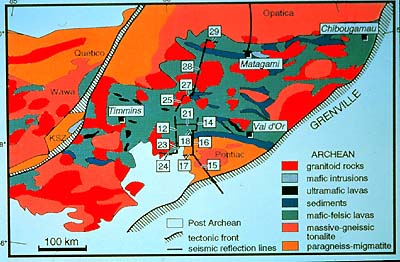
This slide shows the extent of the Abitibi greenstone
belt, the most prominent of its type in the Superior Province. It
is bounded on the southeast by the Grenville Front we looked at
just a minute ago. Another fault borders the belt on the west and
northwest, separating it from the Kapuskasing Structural Zone (KSZ).
Within the greenstone belt occur several types of rock formations
as indicated in the legend. The named townsites are well-known mining
communities, and the Abitibi greenstone belt contains many important
precious and base metal mines.
|