It looks a bit different from other maps in that
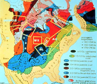
the Baltic Shield is shown where it once had been, and Greenland
is restored to where it had been before it rifted away from North
America. And it shows more detail than the earlier map of tectonic
elements. The yellow boxes outline LITHOPROBE’s 10 study areas
(or transects): SC, Southern Cordillera; SNORCLE, Slave-Northern
Cordillera Lithospheric Evolution; AB, Alberta Basement; THOT, Trans-Hudson
Orogen Transect; WS, Western Superior; KSZ, Kapuskasing Structural
Zone; GL, Great Lakes International Multidisciplinary Program on
Crustal Evolution; AG, Abitibi-Grenville; LE, Lithoprobe East; and
ECSOOT, Eastern Canadian Shield Onshore-Offshore Transect.
Archean Cratons
We already heard that the Archean protocraton is an aggregate of
six former microcontinents, named "provinces" (e.g. Superior
Province). Each of the six provinces is a Late Archean, crustal
aggregate containing variable proportions of Early and/or Middle
Archean crust; they each have an internal, evolutionary history.
Look for the red and purple colours on the slide.
This Archean protocraton has been named Laurentia. It contains the
Slave, Nain, Superior, Wyoming, Hearne and Rae provinces, all former
microcontinents.
The oldest known rocks on Earth, about 4,000,000,000 years old
(that’s 4,000 million years old or 4,000 Ma), occur in the
western part of the Slave Province.
Although each of the six Archean provinces had a different history,
they all have had major crustal growth between 2,800 and 2,600 Ma.
New lithosphere formed from underlying, partially molten rocks.
During the Early Proterozoic, rifting occurred in these oldest
provinces. Subsequently, these Archean microcontinents were welded
together by enormous and lengthy collisions which raised mighty
mountain belts (orogens) between them, primarily from 2,000 to 1,800
Ma. The continent of North America began to take shape.
|