|
|
|
 |
| media > poster > |
| Geological Cross-section of Southern
British Columbia |
|
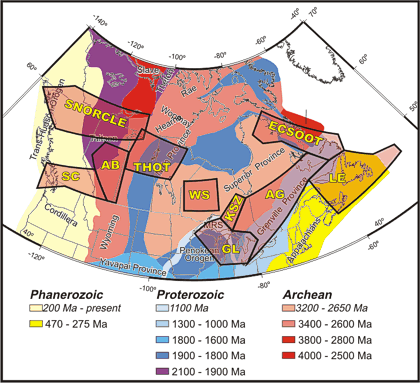 |
Map of northern North America showing major geological units
of the continent and their ages. Black polygons show LITHOPROBE
transects (areas of study). The area of the Southern Cordillera
Transect (SC, outlined by a green polygon), is shown on the map
to the left.
SNORCLE - Slave Northern Cordillera Lithospheric Evolution; AB
- Alberta Basement; THOT - Trans-Hudson Orogen; WS - Western
Superior; KSZ - Kapuskasing Structural Zone; GL - Great Lakes
International Multidisciplinary Program on Crustal Evolution
(GLIMPCE); AG - Abitibi-Grenville; LE - Lithoprobe East; and
ECSOOT - Eastern Canadian Shield Onshore-Offshore. MRS is mid-continent
rift system. |
| poster homepage |
next image |
|
