lithoprobe logo
 
home | contact | search about | transects | publications | links | classroom/media 
 
AB: Alberta Basement


Press Release - Background Information

Photos from the experiment

Participants in the survey
Survey location (maps)
 
Lithoprobe Techniques
Multidisciplinary Studies
Did you know that Ontario once looked like the Himalayas?
What is a seismic reflection survey?
 
 
transects > soss >
Southern Ontario Seismic Survey

Profile Locations

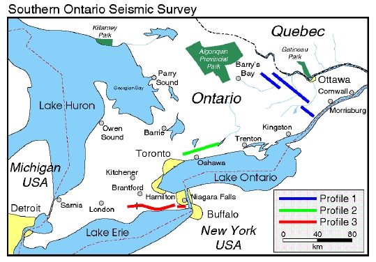
The approximate locations of the seismic profiles are shown in the general map of the region for the survey. The total line length is approximately 410 km. The following is a brief description of the 3 acquisition areas from east to west. Detailed maps of the individual lines are provided as jpg or pdf files for viewing.

  • Profile 1 - approximately 160 km - from Martins Corner (south of Douglas Ontario) to Burnbrae Road (northwest of Brockville). From north to south this profile will include three segments:
    • from Martins Corner to north of Hopetown
    • from south of Arnprior to north of Burritts Rapids on the Dwyer Hill road (RMOC Regional Road 3)
    • from south of Smiths Falls (Hutton Road) to Burnbrae Road north of Lyn Ontario.

    Profile1.jpg (NOTE: 2.0Mb)


  • Profile 2 - 1 segment of approximately 100 km from south of Campbelltown on 4th Line Road to Webb Road in the township of Uxbridge and Bethesda Road in the Town of Whitchurch Stouffville.
     
    Profile2.jpg (NOTE: 1.0Mb)


  • Profile 3 - 1 segment of approximately 150 km along a road network from east of Norwich in Delhi Township, Regional Municipality of Haldimand-Norfolk to 2nd Concession Rd - Bertie Street in Port Colborne - Fort Erie, Regional Municipality of Niagara.
     
    Profile3.jpg (NOTE: 2.3Mb)
 
home | about | transects | publications | links | classroom/media | search | contact