The Globe and Mail,
Saturday, June 20, 1998,
Science, Section D5
BY MICHAEL JUDGE
Special to The Globe and Mail, Winnipeg
Toronto was once higher than the Himalayas, Newfoundland, a
neighbour to Africa. Fleshing out this geological tumult is the
mission of the mammoth LITHOPROBE project, which uses deep-diving
echos to detect Canada's ancient faults and future prospects.
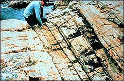 |
| Canada's ancient roots include billion-year-old rock on
the northern shore of Georgian Bay. |
A 25-tonne truck with oversized balloon tires is parked on the
shoulder of a country road. The truck's wheels are hoisted up
so all its weight is bearing down on a giant steel pad that is
vibrating against the ground, kicking up dust and scattering
stones. Nearby, Ron Clowes sits in another vehicle, where computers
click and whir. It might not look like it, but Dr. Clowes is
operating a time machine.
The quavering truck is part of an elaborate echo technique that
peers down through a hundred kilometres of solid stone and back
billions of years into the past. Dr. Clowes, the time traveller,
is a professor of geophysics at the University of British Columbia
as well as the director of LITHOPROBE, a mammoth Canadian earth
sciences research venture. "This is definitely the biggest
Canadian geoscience project ever," he says. "Our aim
is to piece together the jigsaw puzzle represented by Canada's
geography and geology."
Results from LITHOPROBE paint a picture of Canada's origins
stretching back a mind-boggling four billion years. It's hard
to imagine, but there were times when Toronto perched atop a
mountain range that dwarfed the Himalayas, Newfoundland bumped
up against Africa, and Manitoba was under an ocean the size of
the Pacific.
Canada's ancient roots include billion-year-old rock on the
northern shore of Georgian Bay.
LITHOPROBE began in 1984 with the energy of a group of ambitious
geoscientists and financing from the Geological Survey of
Canada and the Natural Sciences and Engineering Research Council.
It was only natural that the most comprehensive project of
its kind in the world should take place here: Canada lays
claim
to some of the oldest - and youngest - exposed rocks on Earth.
In fact, the oldest rocks found on the planet sit about 300
kilometres north of Yellowknife. They are four billion years
old - very respectable when you consider that the Earth itself
is only 4.6 billion years old.
Fourteen years after its inception, LITHOPROBE has involved
the efforts of more than 700 scientists, mapped out enormous
areas of Canada and produced spinoff benefits for the mining
and oil industries. "This project has been an inspiration
around the world," says George Thompson, a professor of
geophysics at California Stanford University. "This has
given us unique information we wouldn't have received any other
way. The results will be exploited for many decades to come."
LITHOPROBE scientists are looking at the stuff of which Canada
is made - our portion of the lithosphere. "The lithosphere
is the relatively rigid outer part of the Earth," Dr. Clowes
says. If the Earth were an orange, the lithosphere would be its
peel. It's not an exact analogy, however, because the lithosphere
is broken up into interlocking tectonic plates, with thicknesses
ranging from 50 to 300 kilometres. And the plates are constantly
moving - at imperceptible speed but with sufficient power to
cause most of the world's earthquakes.
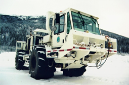 |
| One of the team of vibration-generating
dancing elephants that the LITHOPROBE project uses to discern
what's beneath the surface of the earth. |
An important component of LITHOPROBE's results come from a technique
called seismic reflection. Huge trucks carrying mechanical vibration
units - such as the one operated by Dr. Clowes - are parked on
the surface and pump sound waves into the ground over a range
of frequencies. Four or five of the "dancing elephants" will
work simultaneously, sending sounds down into the rock, where
they will echo back from various underground structures, such
as interfaces between different types of rocks or an ancient
faults. An array of 5,000 sensors on the ground picks up the
returning echoes, and computers crunch the numbers into cross-sectional
pictures going down as far as 100 kilometres.
Used expertly, this is a relatively inexpensive way to get a
good picture of what is underfoot. Seismic reflection has been
used in the past, but only to relatively shallow depths and primarily
for oil exploration. One of the accomplishments of LITHOPROBE,
working together with other groups around the world, has been
to improve this technology so that it can see 10 times deeper
than before, with better resolution.
One of the team of vibration-generating dancing elephants that
the LITHOPROBE project uses to discern what's beneath the
surface of the earth.
These two-dimensional pictures
are fleshed out by looking at variations in the earth's gravitational
and magnetic fields
and its electrical conductivity at various depths. Another
tool is seismic refraction, which measures the speed of sound
waves from an underground explosion.
The age of the rocks, which supplies the important fourth dimension
to the map, is usually determined from isotopic analysis. This
is possible because many rocks contain radioactive elements that
decay into other elements on a precise schedule. Uranium, for
example, will be half changed to lead after 4.5 billion years.
This is on the order of the Earth's time scale, so geologists
measure the relative amounts of the two elements in rocks to
get a good idea of when the rocks formed.
When information from LITHOPROBE is added to what we already
know about our continent, the cosmic drama of Canada's prehistoric
birth unfolds. To see it from the beginning requires getting
into a time machine. Destination: four billion years ago.
Over eons, the first microcontinents formed and then crunched
together to form large continental blocks. Then, almost two billion
years ago, there was a global fender bender. Three enormous,
ancient blocks smashed into one another, welded together and
parked themselves in the vicinity of where Canada sits today. "This
is the glue that has held together the main part of our continent" Dr.
Clowes says. One of the most prominent blocks is technically
called the Superior Province, but we know it better as the Canadian
Shield.
In this early period, between the Shield to the east and the
Hearne-Rae Province to the west, sat the Pacific-sized Manikewan
Ocean. Its eastern shore was near where Thompson, Man., is today.
Fortunately for Prairie farmers, this ocean was eventually squeezed
shut as the two provinces converged like a pair of titanic bulldozers
and were then broadsided by yet other block.
Moving ahead about a billion years, the protocontinent Laurentia
collided with a gigantic land mass on its southeast coast, probably
the biggest collision in Earth's history. The force of this impact
pushed up the largest mountain range that has existed on this
planet, higher than Everest. Southern Ontario once greatly resembled
present-day Tibet.
Nothing lasts forever, though, and these mighty peaks eventually
crumbled under erosion by wind and water. The remnants of the
mountain belt are scattered as far away as the Arctic Islands,
although some remain closer to home, in the form of rocks dotting
the shores of Georgian Bay. At about the same time, in a prehistoric
commentary on Canadian politics, Laurentia was trying to split
in two. A 35-kilometre-deep rift developed through the Great
Lakes region, almost slicing the continent in half.
Continents continued to form and rub shoulders until, by 200
million years ago, the super-continent Pangaea formed, uniting
almost all of Earth's continental crust. Then Pangaea split,
with the southern continents separating first and then breaking
apart in turn to form the South Atlantic.
More recently, about 120 million years ago, the continents that
would go on to become Europe and Asia split away from North America,
forming the North Atlantic. The traces of this departure remain:
The Appalachians, which run from the southern United States up
into Newfoundland, have a twin range in Europe. As that split
proceeded, packages of crust accumulated on the West Coast from
somewhere in the early Pacific Ocean, adding the finishing touches
to British Columbia. Our country was complete.
Of course, Canada hasn't stopped moving just because people
are standing on it now. The Atlantic is still expanding, we continue
to move apart from Europe. And, on the B.C. coast, our continent
is moving westward and grinding over the offshore Juan de Fuca
plate, which is slipping underneath us at the leisurely rate
of about four centimetres a year. It is the potential of these
two overlapping plates to grab and then release suddenly that
leads to earthquakes.
Unfortunately, although LITHOPROBE's scientists have contributed
to a better understanding of the processes at work, even they
can't predict exactly when or where the next big earthquake will
strike.
LITHOPROBE isn't only about the past, though. It is giving Canadian
industry some very up-to-date tools. Mining and oil companies
have contributed millions of dollars to the project and have
received many benefits in return. Black gold, for example. "LITHOPROBE
has contributed to the reinitiation of petroleum probing on the
west coast of Newfoundland," Dr. Clowes says. "This
has indicated potential petroleum reserves. Even if we contributed
only 5 to 10 per cent to this discovery, its value would more
than pay back the entire cost of the LITHOPROBE project."
LITHOPROBE has surveyed many other regions of Canada in cooperation
with natural resource industries. Often the approach has been
to investigate sites where an expensive mining infrastructure
has already been built. Because LITHOPROBE can look so much deeper
than conventional mining probes, it ran help find deposits that
haven't yet been touched.
LITHOPROBE is due to wrap up in 2003, although it will take
many more years before all the information it gathers is fully
interpreted and published. Mapping out almost four billion years
of geological history in two decades is a Herculean task, but,
after all, this is important stuff. "This ties into the
part of the Earth where the energy and materials that drive much
of modern civilization are found," notes Stanford's Dr.
Thompson. It's exciting to watch space missions blasting off,
but it could turn out that it's more important for us to explore
our inner space.
Michael Judge is a science writer based in Winnipeg.
|
