LITHOPROBE Seismic Reflection Studies in Mining Camps
Abitibi-Grenville Transect
Trans-Hudson Orogen Transect
Alberta Basement Transect
Eastern Canadian Shield Onshore-Offshore Transect
INTRODUCTION
LITHOPROBE is Canada's national, collaborative, multidisciplinary Earth
science research project established to develop a comprehensive understanding
of the evolution of the northern half of the North American continent.
Canadian geology is a mosaic, a complex jigsaw puzzle representing four billion years of continental growth, destruction and reorganization (Figure EO-1). How was the current geological configuration established and what were the geological processes
involved in establishing the mosaic? These are fundamental questions in Earth science, ones that have global implications. Canada, with its diverse geology spanning the range of Earth history, is unique as a country in having the
opportunity to investigate how a continent has evolved over such an immense period of time.
LITHOPROBE is exploiting this opportunity on behalf of Canada.
The LITHOPROBE Phase IV Proposal: Studies of the Evolution of a Continent,
proposed two new transects, new directions related to the mantle lithosphere and numerical modeling of lithospheric deformation, and a pan-LITHOPROBE
synthesis, all of which were widely acclaimed and approved through the peer review process. The proposal recognized that the scientific program would have
to extend beyond the normal NSERC 5-year award period and outlined a plan to bring the project to completion within a further 5-year period, a plan which was approved in principle. This document, the LITHOPROBE
Phase V Proposal: Evolution of a Continent Revealed, is LITHOPROBE's response to that opportunity and represents the final phase of this internationally acclaimed project.
To achieve a fundamental understanding of how the northern North American continent evolved requires comprehensive knowledge
of the surface distribution and characteristics of rocks as represented by the geological map of Canada and
it requires comprehensive knowledge of the third dimension, depth, and the fourth dimension, time. For this, application of the panoply of Earth science disciplines is essential; and this application must be done in a collaborative manner by many highly
qualified scientists.
LITHOPROBE brings together all these essential ingredients to fulfill its objective of revealing the evolution of a continent.
LITHOPROBE's principal scientific and organizational components are built around a series of ten transects, or study areas, each of which is focussed on carefully selected and representative geological features of Canada that represent globally significant tectonic
processes. The transects span the country from Vancouver Island to Newfoundland and from the U.S. border to the Yukon and Northwest Territories; and geological time from 4 billion years ago (4 Ga) to the present. Each transect involves an
integrated scientific program spearheaded by the seismic reflection method, because that technique provides the best resolved images
at depth, and including all other applicable geological, geochemical and geophysical subdisciplines which provide the "glue" to bind the program together. In LITHOPROBE
Phase V, the two final transects will be completed and the results from the individual transects will be integrated and synthesized to complete this visionary project.
LITHOPROBE was initiated in 1984 following the efforts of grassroots Earth scientists from the universities and the Geological Survey of Canada (GSC) who recognized the need for a dedicated project of high scientific significance to provide a flagship for, enhance the quality of, and
bring cohesion to, their discipline. Since its Phase I beginning, LITHOPROBE has achieved outstanding scientific results which are represented in about 900 publications involving over 750 separate authors from all sectors -
academia, government and industry.
Almost 500 of these publications and more than 300 new authors have been added since submission of the Phase IV Proposal in January 1993. Through these publications and the integration of information from them,
LITHOPROBE is generating a comprehensive new perspective on the development and evolution of the Canadian landmass. The data and interpretations are providing a new base from which the petroleum and mining industries can better develop their exploration strategies,
a new understanding of plate tectonic interactions on the west coast and the associated earthquake hazards, and a legacy of Earth science information that will be used for many years to come.
The present LITHOPROBE Phase V Proposal seeks approval and support for completion of our scientific program to reveal the evolution of a continent.
Without such completion, the previous investments of scientific effort and funds in this comprehensive research program carried out over the past 13 years will not be capitalized upon and the scientific and
educational impact will be substantially reduced. Figure EO-2 summarizes the past and future scientific activities and plans of
LITHOPROBE for its full duration. During Phase V, four transects [Abitibi-Grenville,
Trans-Hudson Orogen,
Alberta Basement and
Eastern Canadian Shield Onshore-Offshore],
for which expenditures for scientific activities are complete,
must be brought to a scientific synthesis and conclusion.
Two transects [Western Superior
and Slave-Northern Cordillera Lithospheric
Evolution] must
complete their scientific programs to fulfill the long-standing objective of
investigating all of the key geological targets in Canada representing nearly
the full period of Earth history; and these programs must be brought to a
synthesis and conclusion.
Phase V, the concluding phase of LITHOPROBE,
is the period during which the continental-scale results and global implications about the nature and mechanisms of tectonic processes to be derived from these results will be emphasized through a pan-LITHOPROBE
synthesis involving all transects. The scientific program of the project has been directed to such an achievement for a decade. Now is the time to ensure that this achievement will be realized.
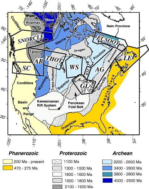
Figure EO-1. Area of LITHOPROBE transects superimposed on a simplified tectonic element map of North America. Transects are: SC - Southern Cordillera;
SNORCLE - Slave-Northern Cordillera Lithospheric Evolution; AB - Alberta Basement; THOT - Trans-Hudson Orogen; WS - Western Superior; GL - Great Lakes International Multidisciplinary Program on Crustal Evolution (GLIMPCE); KSZ - Kapuskasing Structural Zone;
AG - Abitibi-Grenville; LE - LITHOPROBE East; and ECSOOT - Eastern Canadian Shield Onshore-Offshore Transect.
PROPOSED SCIENTIFIC PROGRAM -
LITHOPROBE PHASE V,
EVOLUTION OF A CONTINENT REVEALED
Overview
Outstanding scientific results have been achieved during
LITHOPROBE Phase IV. However, the ultimate objective of revealing the evolution of a continent and understanding the tectonic processes involved in that
evolution cannot be achieved without (i) completion of scientific studies in two transects, Western Superior and SNORCLE; (ii) synthesis of results from the four transects - Abitibi-Grenville, THOT, Alberta Basement and ECSOOT - most
active during Phase IV; and (iii) the opportunity to carry out the pan-LITHOPROBE synthesis.
To ensure that this objective is reached, the present momentum of the science and the many scientists involved must be maintained, requiring a continuation of the organizational infrastructure. To ensure that the legacy of
LITHOPROBE data is archived appropriately, that these data are integrated into the synthesis in a consistent manner, and that the development of new analysis procedures by
LITHOPROBE scientists continues and is applied to the geophysical data sets, the
LITHOPROBE Seismic Processing Facility must be maintained as a viable entity.
LITHOPROBE Phase V is required to bring the project to its planned conclusion. Without this final investment to ensure completion of the project as a unified entity, the prior investments from all sources during the past 13 years will not be capitalized upon.
LITHOPROBE Phase V will complete one of the most visionary Earth science projects ever undertaken worldwide, a project that has developed, and will continue to develop fundamental new scientific understanding, contribute significantly to
Canada's economic and social benefit and bring further international renown to Canadian Earth science.
Western Superior Transect
The continental nucleus of North America was assembled during the Archean eon. The Western Superior and SNORCLE transects incorporate studies of two of the best exposed and most representative Archean cratons in the world.
LITHOPROBE would be remiss in not investigating them to the maximum extent possible. The Archean Superior Province in Canada is the largest component of the Precambrian nucleus of North America and is best exemplified by its exposure in northwestern Ontario and
eastern Manitoba. The internal geometry of
the Superior Province in the transect area is dominated by a pattern of 100-200 km wide, late Archean, east-west trending lithotectonic belts representing oceanic crust, island arcs, sedimentary prisms and continental fragments. The Western Superior
Transect provides a unique laboratory worldwide for testing the hypothesis that Archean continental lithosphere formed as a result of accretionary tectonics. The transect scientific program is developed around two principal objectives: (i) to investigate
the relationships between and within
subprovinces at depth in order to understand further the processes involved in the formation, assembly, and stabilization of late Archean crust; and (ii) to determine, compare, and contrast lithospheric structure beneath subprovinces of different tectonic origin.
These objectives are being addressed through a scientific program which focuses on four complementary study corridors, each of which addresses unique aspects of the geology of the region.
- Corridor 1, running north-south in the central part of the transect area, forms the principal and most extensive corridor possible and addresses regional lithospheric structure.
- Corridor 2, running north-south in the western part, crosses characteristic, and the best preserved, belt patterns and fundamental subprovinces absent along Corridor 1.
- Corridor 3, a short segment in the eastern transect area, tests the accretionary hypothesis by crossing the historical type area presented for the existence of Archean accretionary complexes.
- Corridor 4, extending orthogonally to corridors 1-3, provides important constraints on the true 3-D orientation of structures and examines a prominent geological feature believed to be a tectonic "indentor".
NSERC LITHOPROBE supporting geoscience studies were initiated in 1993-94, building on the geological data base provided by the Ontario Geological Survey (OGS). The research has focussed on four broad themes:
structural studies of contact relationships, sedimentary-geochronological
studies, regional geochemical and isotopic studies and metamorphic studies; plus a teleseismic experiment to determine upper mantle structure underlying the region. Field mapping projects combined with dating studies continue at the OGS.
The first major geophysical experiment, a refraction/wide-angle reflection survey
to characterize the seismic velocity structure of the crust and upper mantle, including the effects of anisotropy, was successfully completed during July 1996. The first stage of the transect's
seismic reflection program, 800 km of new data to provide subsurface images in Corridors 1 and 2, is being carried out during October - November 1997.
The LITHOPROBE Phase V Proposal requests funds to ensure completion of the scientific program.
- Continuation of university-based supporting geoscience for 1998-99 and 1999-2000 using the well-established and respected internal grants competition procedure; the overall focus of projects will be deriving additional results from near-surface studies
and determining the significance of these results for extrapolating and constraining the three-dimensional geological structure along the transect corridors. The newly established Western Superior National Mapping (NATMAP) project (1997-2002), supported
by the GSC, OGS and Manitoba Geological Services Branch, was planned to complement the scientific program of the LITHOPROBE transect.
- Second stage of multichannel seismic reflection acquisition in 1999-2000: 350 km of data to test the prototype Archean
accretionary model in Corridor 3, to provide constraints on the 3-D nature of structures and to address critical targets that arise from the Stage 1 survey or other studies.
- Electromagnetic surveys, principally using the magnetotelluric (MT) method, are planned for 1998-99 with two main objectives: determining the electrical conductivity structure associated with boundaries of the two principal metasedimentary subprovinces
and mapping the conductivity structure of the lithosphere, laterally and vertically, using a 2-D grid of MT stations.
- Digital data management and transect synthesis is essential to bring the transect program to its planned conclusion.
Without full completion of the Western Superior Transect scientific program, this classic cratonic core of the North American continent will not be adequately investigated, leaving a void at the heart of LITHOPROBE's
cross-Canada studies and at the core of an ongoing geological problem.
Slave-Northern Cordillera Lithospheric Evolution (SNORCLE) Transect
The oldest known rocks on Earth are about 4.0 Ga and occur in the Slave geological province, a relatively small Archean craton in the Northwest Territories (NWT). To the southwest, into the Yukon and northern British Columbia, progressively younger
(Paleoproterozoic through to Cenozoic) rocks and structures, resulting from
accretionary and transpressional tectonic processes that continue to the present day, record the westward growth of the North American continent. The overall objectives of the SNORCLE
transect are to investigate the structure and growth cycles of continental lithosphere, and the processes associated with those growth cycles, in one of the few regions on Earth where the rock record spans 90% of Earth's history. Some of the specific
questions to be addressed are: Is the tectonic style of Early Archean continental nuclei unique? How have 4 Ga cratons been modified since the Archean? Are structures and processes of Proterozoic orogens fundamentally different from those of Phanerozoic orogens?
Why is the 2,500 km-long foreland basin of the Cordilleran Orogen much more extensive, both areally and vertically, in the south (Alberta) than in the north (northwestern Canada)? How were outboard Cordilleran terranes assembled to produce the present
distribution of exotic elements?
Although the transect region encompasses a large area (Figure EO-1) research is being focussed in three principal study corridors:
- Corridor 1 in NWT includes the Archean and Paleo-, Meso- and Neoproterozoic elements of the transect.
- Corridor 2 in northern British Columbia includes Meso- and Neoproterozoic elements in the east and extends from the Paleozoic miogeocline, through the foreland of the northern Cordillera, across the Tintina fault (a fundamental crustal break), into accreted
terranes and as far west as the Coast belt where it links with a U.S.-funded project, ACCRETE.
- Corridor 3 in the Yukon crosses the deformed outer miogeocline, another segment of the Tintina fault and into a series of Paleozoic and Mesozoic accreted terranes.
NSERC LITHOPROBE supporting geoscience studies in all corridors began in 1994-95 and are complemented by government-funded studies. They have provided an abundance of new information. For example in Corridor 1, such research includes a detailed study of exposed rocks
representative of the middle and deep crust, studies of Archean sediments and associated rocks to shed light on evolution of supracrustal sequences, and examination of crustal and mantle xenoliths provided by
diamond companies. In Corridors 2 and 3, only supporting geoscience research has been conducted, covering a wide range of geological, geochemical and geophysical topics and involving scientists from the universities, GSC, B.C. Geological Surveys Branch and
the Yukon Geology Program.
The first major geophysical activities, multichannel seismic reflection and magnetotelluric (MT) surveys, were carried out along Corridor 1 in late 1996. Preliminary images from the reflection data are spectacular and clearly
illustrate structures and processes involved with Proterozoic-Archean and Proterozoic-Proterozoic collisions of continental blocks. They also demonstrate the critical need to continue such profiling to the west of current coverage. Unprecedented results
are deriving from the MT survey. As one example, the Anton terrane of the Slave craton shows no conducting lower crust, a contrast to all other Archean cratons. This lack of a conducting lower crust means that there is sensitivity to the actual resistivity
of the lowermost continental crust and uppermost mantle, such that an "electrical Moho"
is defined for the first time. The seismic refraction/wide-angle reflection (R/WAR) experiment was carried out during August-September 1997 to determine velocity
structure of the crustal and sub-crustal lithospheric mantle of the tectonic elements crossed by the profiles in the three corridors.
The LITHOPROBE Phase V Proposal requests funds to ensure completion of the scientific program.
- Continuation of university-based supporting geoscience for 1998-99 through to 2000-01, also using the internal grants competition. These will be complemented by a range of studies supported by the GSC, NWT Geology Division, Yukon/Canada Geology Program and the B.C. Geological Surveys
Branch, partly through the Post-Slave NATMAP program (1997-98 to 2000-01) and planned Northern Foothills NATMAP project (1998-99 to 2002-03); both projects are established to coordinate with SNORCLE Transect. A wide range of geological, geochemical,
dating and geophysical studies are planned by all sectors.
- Extension of MT studies in Corridor 1 further northeast into the Slave craton (1998-99), funded about 60% by industry, the balance from funds in Phase IV. Because of exceptional results in 1996, such as defining the base of the
"electrical lithosphere", diamond mining companies want to support this extension to the region of diamond mine development.
- Multichannel seismic reflection surveys along Corridor 2 (1998-99) and Corridor 3 (1999-2000).
Allowing for an offset along strike, Corridor 2 (Fort Nelson, BC to Watson Lake, YT to Stewart, BC) continues Corridor 1 and will provide subsurface images from the sedimentary basin in the east, with its underlying Proterozoic basement, through the
foreland of the Cordillera to the accreted hinterland as far west as the Coast Plutonic Complex, where it links with a similar U.S.-funded project, ACCRETE. Corridor 3 (Macmillan Pass in the Yukon along the Canol road to near Skagway, Alaska) will provide
complementary images from the deformed outer miogeocline in the northeast, a region key to understanding the evolution of the former passive margin, through North American strata then into accreted terranes in the southwest.
- MT surveys in Corridors 2 and 3 in 1999-2000. Three principal aspects will be addressed: characterization of regional electrical conductivity properties of the northern Cordillera, determination of the depth of the lithosphere and its internal variation
below the northern Cordillera, and subsurface geometry of the Tintina fault system.
- Digital data management and transect synthesis is essential to bring the transect program to its full and planned completion.
The SNORCLE Transect provides a unique opportunity to investigate how continental lithosphere was constructed and modified during most of Earth's history. The opportunity to evaluate the interaction of fundamental tectonic processes through time distinguishes this study and makes SNORCLE an essential and timely transect to bring the
LITHOPROBE transect scientific program to a fitting conclusion.
Completion of Transects Active during LITHOPROBE Phase IV
The data acquisition components, and much of the analyses, associated with the scientific programs in four transects (Abitibi-Grenville, THOT, Alberta Basement and ECSOOT) most active during Phase IV are complete or nearly so. Results to date are presented
in Chapter 3. However, further analyses, interpretation, syntheses and integration of the transect programs will continue into LITHOPROBE
Phase V. Within this proposal, funds are requested to enable continuation of the coordination, digital data management and publication of syntheses for these transects to bring each to a successful conclusion.
LITHOPROBE considers these activities as essential components of the transect scientific programs. Without them, the full scientific impact of the many studies in a transect will not be realized.
Pan-LITHOPROBE Synthesis and Tectonic Processes
Phase V includes a unique new component, pan-LITHOPROBE synthesis. Integration and synthesis of the comprehensive, multidisciplinary results from all ten LITHOPROBE
transects representing tectonic evolution and processes over most of Earth history, is an opportunity that no other Earth science project has had. Exploiting this opportunity is an essential responsibility that must be fulfilled and can only be achieved
with effective support from Phase V. Within
LITHOPROBE, "synthesis" refers to a spectrum of related activities, of which there are four principal ones.
- The assembly and presentation of data/results for the landmass and offshore margins of Canada covered by
LITHOPROBE transects. This element will include maps, other data and explanatory text on a continental scale of a number of important lithospheric parameters that lead to better understanding of evolution and processes affecting it; for example, surface geology,
geochronological and petrological data, gravity, magnetic field, crustal thickness variations, average crustal and uppermost mantle velocities, electrical conductivity structure and heat flow variations.
- Current large-scale structure and the reconstruction of geometrical and kinematic evolution, addressing the theme
"evolution of a continent revealed". Two unique lithospheric cross-sections -
one extending for more than 5000 km from the Pacific Ocean to the Labrador Sea; a second extending from the Archean craton in the Northwest Territories to one of the youngest orogenic belts at the Pacific coast
will be unrivalled in terms of the constraints available for their preparation. The superb geochronological data base, much of which has been added through
LITHOPROBE studies, provides the kinematic framework; and the
LITHOPROBE data and results, coupled with the pre-LITHOPROBE foundation, provides the geometry.
- Examination of LITHOPROBE data (together with data from elsewhere as appropriate) for evidence of common and disparate/peculiar/distinctive processes. One of the unique results from LITHOPROBE is the
opportunity to compare lithospheric structures, characteristics and processes associated with many fundamental tectonic features representing critical geological time periods on the basis of interpretations derived from similar multidisciplinary data sets.
Such comparisons lead to new insights on processes of tectonic evolution. There is no comparable comprehensive data set in the world by which such comparisons can be made.
- Investigations of the nature and mechanisms of the tectonic processes associated
with lithospheric evolution. This will be achieved by considering a series of themes, for which the LITHOPROBE
transect data sets and interpretations derived from them form the bases. Four such exemplary themes are: (i) variations and styles of tectonic processes through time and space, this theme involving LITHOPROBE's
continuing research on geodynamic modeling and its applications; (ii) crustal growth, preservation and recycling of continental crust, particularly with respect to two end-member viewpoints, the `no growth' model
and the `progressive growth' model; (iii) magmatic, metamorphic and tectonic processes, of which a broad range are being investigated throughout the LITHOPROBE
transects, to learn more about the generic aspects of heat transfer between the upper mantle and crust; and (iv) lower crust, Moho and mantle lithosphere for which LITHOPROBE,
through its various multidisciplinary studies, will have one of the most comprehensive data bases that is available anywhere to elucidating the nature and temporal evolution of sub-continental crust-mantle interaction.
The pan-LITHOPROBE synthesis is a critical component of LITHOPROBE
Phase V. By the time of formal completion of the project in 2003, our enhanced understanding of the present configuration and structure of the diverse tectonic elements that form our country, and of the geological processes that created the continent as
we now see it, will represent a quantum leap forward.
The LITHOPROBE
Seismic Processing Facility [LSPF]
LITHOPROBE's multidisciplinary scientific program is spearheaded by the seismic reflection method because reflection images provide the most directly applicable information at depth.
The LITHOPROBE Seismic Processing Facility (LSPF) is an established and efficient research partnership between the central site, located at the University of Calgary, and its associated national network of seismic research nodes, located at nine universities and three
offices of the Geological Survey of Canada. The LSPF was set up in
recognition of the need to fully exploit the extensive, and expensive, database of seismic reflection data to be acquired during the lifetime of the project. Maintenance of the LSPF is essential to ensure completion of scientific, synthesizing and archival
activities throughout Phase V.
The purpose and objectives of the LSPF and seismic research nodes are to provide:
- a quality, uniform seismic processing system for optimizing subsurface
images of geological features;
- facilities for development and implementation of new image enhancing software, primarily for the specific needs of crustal reflection data;
- a central facility for training of personnel, including graduate
students, research assistants and faculty, in state-of-the-art seismic data processing techniques;
- a central facility for storage and rapid access of LITHOPROBE and related digital data (e.g., seismic reflection, seismic refraction and magnetotelluric data); and
- a central facility for storage and processing of digital seismic data that
have been donated to LITHOPROBE.
Major functions of scientific activity at the LSPF and seismic research nodes that will continue throughout LITHOPROBE Phase V include:
- processing of newly acquired reflection data at the LSPF rather than by industry contractors (begun with SNORCLE 1996 survey) in order to reduce costs and because adequate experienced personnel and facilities are now available;
- careful reprocessing of subsets of the data, or even of entire profiles as new techniques are developed, to optimize interpretations;
- processing of data acquired through industry donations, often from field tapes with parameters appropriate for imaging crustal structures;
- preparing reflection data from all transects into seismic images which are consistent and in a common display format for a LITHOPROBE seismic atlas and pan-LITHOPROBE syntheses;
- development of new processing techniques, particularly relevant for lithospheric data, testing, documenting and distribution through the LSPF;
- archiving of reflection, refraction and magnetotelluric data; and
- education and training of users of the seismic processing system through three-to-four short courses (to date, 19 courses involving a total of more than 80 participants have been held), a newsletter, and other means.
These capabilities are just as essential during LITHOPROBE Phase V as they have been during the previous phases of the project.
LITHOPROBE Archives and the Data Legacy
From the inception of the project, LITHOPROBE has recognized the necessity of archiving its scientific data. The LSPF maintains the archive of digital seismic reflection, seismic refraction and electromagnetic data acquired by, and donated to, LITHOPROBE.
As part of its mandate, the GSC maintains the national gravity and magnetic databases. Following affordable availability in the 1990's of computer technologies associated with Geographical Information Systems (GIS), Internet websites, CD ROMS, etc.,
LITHOPROBE established digital data management capabilities within transects
active during Phase IV to incorporate other geoscience data for the purposes of archiving and transect synthesis. Working with the GSC, who are leaders in its applications to the geosciences, transect digital data coordinators are developing and applying
these procedures for analysis, displays, and data management and archiving. Digital data management is a fundamental component of LITHOPROBE Phase V. The coordinated and consistent archiving of LITHOPROBE
data from all transects will provide the bases for syntheses and an unprecedented legacy of high quality data for future research.
Following completion of LITHOPROBE, the GSC with a mandate "to provide Canada with a comprehensive geoscience knowledge base contributing to economic growth...", is planning to incorporate the data archival and dissemination components of the LSPF into its existing infrastructure.
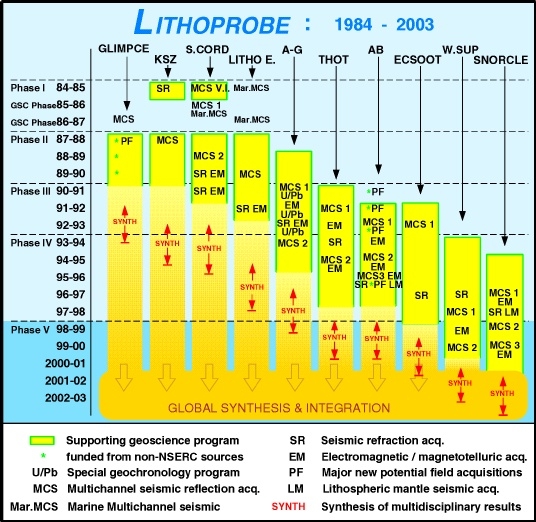
Figure EO-2. Summary of LITHOPROBE scientific activities and work plan for the lifetime of the project,
1984 - 2003. Phases II and III are shown as 3-year periods and Phases IV and V as 5-year periods, consistent with the funding profile and peer review processes established by NSERC. Phase V will bring the project to a logical and planned conclusion. Transects
are: GLIMPCE - Great Lakes International Multidisciplinary Program on Crustal Evolution; KSZ - Kapuskasing Structural Zone; S. CORD - Southern Cordillera; LITHO E. - LITHOPROBE
East; A-G - Abitibi-Grenville; THOT - Trans-Hudson Orogen; AB - Alberta Basement; ECSOOT - Eastern Canadian Shield Onshore-Offshore; W.SUP - Western Superior; and SNORCLE - Slave-Northern Cordillera Lithospheric Evolution.
LITHOPROBE - THE CANADIAN RESEARCH NETWORK FOR THE STUDY OF THE CONTINENTAL LITHOSPHERE
LITHOPROBE is a research network of excellence that spans the country.
LITHOPROBE's scientific program requires a multidisciplinary approach involving collaboration among scientists from universities, government geological surveys and industry. Undergraduates, graduate students, postdoctoral fellows and other personnel contribute
immensely to the scientific studies and learn from them. A unique organizational structure provides direction and ensures coordination. An active program of public outreach brings the exciting scientific results to a broader audience th
an the interested Earth scientists.
LITHOPROBE brings wide-ranging benefits to Canada.
Multidisciplinary Studies - The Key to Understanding
To provide the clues with which the mysteries of the formation of a continent will be revealed requires application of the diverse methods by which geoscientists study and probe the Earth. From its inception, LITHOPROBE
was planned as a coordinated, multidisciplinary scientific project. The rocks of Canada contain the geological and geochemical clues by which the
mysteries will be solved, but their exposure at or near the surface is limited. Thus indirect methods of exploration, those used in geophysical studies, must be employed to locate and define subsurface features. The seismic multichannel reflection method spearheads LITHOPROBE's
scientific program because this geophysical technique produces the best-resolved images of boundaries between rock units and of structures in the subsurface. Seismic refraction and deep-probing electromagnetic surveys provide
essential complementary information about the subsurface. Geological mapping and structural studies develop a framework for interpretations. Potential field data (gravity and magnetics) provide a means of extrapolating results beyond limited outcrops or
profiles. Geochemical analyses enable characterization of the blocks involved in continental amalgamation. Geochronology gives the essential kinematic information by which evolution can be determined. Other geological and geophysical studies provide
necessary supporting information. Through this integrated, multidisciplinary approach, results are enhanced well beyond those which could be achieved through one, or even just a few, subdisciplines.
For LITHOPROBE, the key to understanding the evolution of a continent rests with its multidisciplinary scientific program.
Participation - The Key to Accomplishment
To ensure the success of multidisciplinary research, a network of well-qualified, collaborating scientists also is required. Widespread participation from the geoscientific community is a key to the accomplishments and success of LITHOPROBE.
More than 750 scientists from almost every university earth science department in Canada, all relevant scientific divisions of the Geological Survey of Canada (GSC), most provincial/territorial geological surveys, and many petroleum and mining exploration
companies have been or are involved. During the four-year period, 1993-94 to 1996-97, statistics compiled by the LITHOPROBE Secretariat show 772 person years of participation in the project. One of LITHOPROBE's
ingredients for success is its openness for participation. All interested Canadian geoscientists and those from other countries who desire to become involved can do so using their own research resources. The University Supporting Geoscience Projects
annual open grants competition provides a focus for involvement of the university community. However, this community also directs much of its other research funding toward LITHOPROBE studies; from 1993-94 to
1996-97, this funding totaled $4.23 M. Government geological surveys align significant elements of their human and scientific resources with the LITHOPROBE scientific program. To illustrate the quality of scientists associated with LITHOPROBE
and the range of geoscientific specialties they bring to the project, Appendix B includes a list more than 40 actively participating scientists who will be contributing to the scientific program of Phase V. The participation and commitment by large numbers
of scientists across the country and from all sectors makes LITHOPROBE work as a project and distinguishes it from most other projects.
Training of Highly Qualified Personnel
A significant component of the scientific participation in LITHOPROBE
involves graduate students, postdoctoral fellows, research assistants/associates and undergraduate students. They are receiving their education in an environment of stimulating, collaborative, multidisciplinary research. These young scientists are a
resource for Canada's future, a pool of expertise highly trained in their specialties, but familiar with the broad-based activities of a multidisciplinary program.
LITHOPROBE `graduates' are already contributing to industry, government service and academia.
Since its inception, participation in the LITHOPROBE
scientific program by young scientists numbers more than 400 persons. During the period of Phase IV for which statistics are available (1993-94 to 1996-97), scientists who are receiving training and education represent
almost 500 person years of involvement in the project.
Considered by group, the `person-year'
totals for the period are: M.Sc. students - 117; Ph.D. students - 115; postdoctoral fellows and research associates - 92; undergraduate students - 111; and research assistants and technicians - 63. Such training and education will continue throughout
LITHOPROBE Phase V, but at a decreasing level consistent with the decreasing scientific activities as the project is brought to a conclusion.
The Network - Partnerships and Interactions with Government and Industry
The Geological Survey of Canada
The Geological Survey of Canada (GSC) is an active and formal partner in all aspects of LITHOPROBE
in all regions of the country, and will continue this partnership throughout Phase V. The partnership has been formalized through an annual statement to NSERC of the expected financial contribution of the GSC to the project and by two representatives on
the Board of Directors. During Phase IV, the annual GSC contribution to LITHOPROBE scientific activities, exclusive of staff salaries, averaged about $2.0 M per year; the annual commitment was stated as a minimum of $1.6 M. During
LITHOPROBE
Phase V, the GSC is committing to a similar or greater percentage contribution to the scientific program relative to the requested funds from NSERC. If the in-kind contributions of staff salaries were included, the estimated contribution from the GSC
increases by about 75%.
The GSC commitment to partnership with LITHOPROBE for Phase V is exemplified strongest by the fact that most of the activities in their
"Bedrock Geoscience Program" are being oriented for the next five years to studies in the western Superior Province, the Slave Province and the northern Cordillera, these areas being associated with the Western Superior and SNORCLE transects.
The GSC has been, and will continue to be, a full partner with NSERC researchers in the planning, operational management and strategic decision-making of the LITHOPROBE scientific program.
This involvement includes participation on the Board of Directors, Scientific Committee, all advisory subcommittees, transect leadership, transect research teams and specialized working groups for all transects. This unwavering and integral commitment by
the GSC to LITHOPROBE is one of the principal factors behind the project's sustained scientific success and international reputation for scientific excellence.
LITHOPROBE has defined the global standard for collaborative government-university geoscience programs.
The GSC's scientific contributions to LITHOPROBE
have been and will be focussed on regions where national mapping (NATMAP) projects are linked with transect scientific programs, although GSC contributions include most transects during their active periods. Examples of previous NATMAP linkages include
the Shield Margin NATMAP project and Trans-Hudson Orogen Transect, Slave Province NATMAP project and SNORCLE Transect, and Magdalen Basin NATMAP project and LITHOPROBE East Transect. A current close linkage exists between the GSC's
South Baffin project and ECSOOT. Since the beginning of LITHOPROBE, the GSC has aligned its regional scientific programs, and some of its specialized research related to mineral exploration, with the project's
research program.
The model for real-time linking of scientific programs is the Trans-Hudson Orogen
Transect-NATMAP partnership, designed from the outset to jointly realize transect objectives and NATMAP project goals and create a critical mass of researchers (universities, GSC, Saskatchewan and
Manitoba geological surveys) working in a coordinated and collaborative fashion.
During LITHOPROBE Phase V, new NATMAP linkages are or will be established to enhance the scientific programs of continuing active transects.
Some of these and additional major activities to which GSC scientists will contribute and GSC funds will be directed are noted below.
- Western Superior NATMAP Project
which, extending from 1996 to 2001, overlaps both temporally and geographically with the Western Superior Transect.
- Seismic reflection and electromagnetic (magnetotelluric) surveys in the Western Superior Transect.
- Post-Slave NATMAP project, a 4-year extension to 2000 in recognition of SNORCLE Corridor 1 activities and the increased interest in the Slave Province following the diamond discoveries.
- Seismic reflection and magnetotelluric surveys in Corridors 2 and 3 of the SNORCLE Transect.
- Planned 5-year Northern Foothills NATMAP Project
(1998-99 to 2002-03) which will contribute to studies in the region of the foreland basin (eastern Cordillera), part of SNORCLE Corridor 2.
- Proposal in development for a Yukon-Tanana NATMAP project which will complement SNORCLE Transect Corridor 3.
- Research and development in GIS and digital data management, analysis, integration and interpretation to aid LITHOPROBE researchers and contribute to the pan-LITHOPROBE synthesis.
The Geological Survey of Canada has spoken out unequivocally that the scientific program of LITHOPROBE Phase V is one of its high priorities.
Continuation of support from NSERC as requested in this Phase V proposal is essential to realize the full scientific impact of these established priorities.
Provincial and Territorial Geological Surveys
The LITHOPROBE partnership also includes scientists from provincial and territorial geological surveys,
when activities of a transect are within their areas of jurisdiction.
A representative of these organizations sits on the Board of Directors to ensure communication about their activities and LITHOPROBE
developments. ECSOOT is co-led by a scientist from the Newfoundland Geological Survey Branch. The Ontario and British Columbia geological surveys have appointed LITHOPROBE
liaison representatives to the Western Superior and SNORCLE transects, respectively. The key scientific contribution of provincial/territorial surveys to the project are
geological mapping, thematic research such as geochemistry, and regional compilation and tectonic synthesis.
Based on statistics provided by the surveys,
the value of their contributions for the period 1993-94 to 1996-97 is estimated at $3.23 M. Geological surveys involved were from British Columbia, Alberta, Saskatchewan, Manitoba, Ontario, Quebec, Newfoundland and the Yukon.
During LITHOPROBE Phase V, some of the activities and programs to which provincial/territorial geological surveys will be contributing are:
- THOT data, interpretations and syntheses by the Saskatchewan Geological Survey and Manitoba Geological Survey Branch;
- ECSOOT scientific interpretations, digital data management and synthesis by the Newfoundland Geological Survey Branch;
- Western Superior Transect mapping, analyses and interpretations through the Western Superior NATMAP project by the Ontario Geological Survey and Manitoba Geological Survey Branch; and
- SNORCLE Transect mapping, analyses and interpretations through the Post-Slave NATMAP project by the Government of NWT, the planned Northern Foothills NATMAP project by the Government of the NWT, Alberta Geological Survey and B.C.
Geological Survey Branch, and the developing Yukon-Tanana NATMAP project by the Yukon/Canada Geology program.
LITHOPROBE has defined the style of partnered geoscience research for the future. National programs that provide broad-scale regional geoscience knowledge will be delivered jointly
between the GSC and provincial/territorial partners bolstered by contributions from university geoscientists.
Industry Participation
Mining and petroleum industry representatives serve on the Board of Directors, Scientific Committee and some disciplinary subcommittees. Both industry sectors contribute to LITHOPROBE
scientific programs when they perceive value to their ongoing exploration efforts, whether through new data or interpretations of regional geological framework. Such participation involves direct financial contributions and in-kind support for specific
studies. During the 1993-94 to 1996-97 period of Phase IV, direct financial contributions toward LITHOPROBE scientific activities totaled $2.29 M.
In-kind contributions are more difficult to estimate, but during the same period at least $1.2 M in value was involved.
LITHOPROBE's past procedures and success, industry contributions often are only expected to be realized within the year in which a given activity is taking place; this follows from the manner in which industry assigns funds for such work. In addition to industry's
continuing advisory role during Phase V, we expect support for a number of scientific activities; a few examples follow.
- Two diamond companies have committed $100 K
to enable a 1998 extension of the 1996 SNORCLE magnetotelluric survey northeastward to the region of diamond mine development in the Northwest Territories.
- Existing mines in the Western Superior Transect and SNORCLE Transect will provide drillcore samples for laboratory studies.
- Diamond companies will provide kimberlite samples from their exploration activities in the Slave Province of SNORCLE Transect, from which mantle xenoliths will be studied by university and GSC scientists.
- Petroleum industry direct support of about $250 K is anticipated for SNORCLE reflection acquisition in NE British Columbia in Corridor 2 in 1998-99.
- Mining industry support for joint electromagnetic studies and for high resolution seismic acquisition in stage 2 of the reflection surveys in Western Superior Transect is anticipated.
Organizational and Management Structure - A Coordinated Network
LITHOPROBE is a decentralized network of scientific studies and collaborating
scientists from across the country, but one that still requires centralized coordination. Thus a specialized organizational structure has been developed to ensure LITHOPROBE's
role as a national scientific program. The Board of Directors has ultimate responsibility for all programs, policies and expenditures; and is accountable to NSERC and the GSC for the efficient, effective and economical operation of
LITHOPROBE. The Board presently comprises 11 members nominated by the two funding agencies and the Canadian Geoscience Council (CGC) and is appointed by NSERC and the GSC; one NSERC representative sits on the Board as an Observer.
The remainder of the organizational structure consists of operational and advisory components. Details are described in Appendix E and current membership of its components are listed in Appendix F.
Advisory Component
The advisory component of LITHOPROBE's organizational structure comprises the Scientific Committee and a number of subcommittees.
- The Scientific Committee is the
senior scientific advisory body whose responsibility is to ensure the most effective scientific and technical direction for the project. It comprises 11 highly regarded scientists active in the broad range of multidisciplinary studies applied in LITHOPROBE.
- Three discipline-based subcommittees -
Geology & Geochemistry, Electromagnetic & Other Geophysics, and Seismic & LITHOPROBE Seismic Processing Facility
provide recommendations and advice on a range of scientific matters related to the applicable disciplines and the application of those disciplines in all transects.
- The University Supporting Geoscience Projects Subcommittee is established each year with a rotating membership to provide an objective and thorough peer evaluation of applications received for the annual internal grants competition through which many academic
scientists receive support for scientific investigations of relevance to the project. Procedures follow as closely as possible those established by NSERC for its grant selection committees, including the use of external referees.
- The Pan-LITHOPROBE Subcommittee was established in 1996 to provide advice, direction and comments on
LITHOPROBE scientific activities as they pertain to the synthesis of transect activities and what has been learned about the overall structure and evolution of the North American continent and the processes involved in that evolution.
Operational Component
The operational component comprises the Project Director, Secretariat, LITHOPROBE Seismic Processing Facility and the transect network.
- The Project Director is the head of the project, providing overall scientific leadership, direction, coordination and communication.
- The Secretariat, headed by the Project Director, is the central network node which provides communication and coordination for all components of the project. In addition to the Director, it comprises an Operations Manager (to March 1998), an Administrative
Assistant, a Secretary and a half-time communications adviser. The NSERC grant for LITHOPROBE is awarded to the Director.
- The LITHOPROBE Seismic Processing Facility is an effective component of the project that was discussed previously.
- A network of Transect Teams, each headed by a Transect Leader(s) and comprising scientists from all sectors who are actively participating in the scientific programs, are the key to achieving the scientific objectives of the transects.
A testament to the success of this organizational structure is the fact that other groups, nationally and internationally,
who are attempting to establish other centres of excellence, use it as a model for organizing effective collaborative research. Indeed, NSERC has directed a number of principal investigators for a variety of studies to the LITHOPROBE
Project Director for information on organizational and management aspects of a large, networked project.
Communications/Public Outreach - LITHOPROBE Tells Its Story
To achieve the necessary communication of LITHOPROBE's exciting result beyond the interested Earth science community, LITHOPROBE
established a public outreach strategy coordinated by the Secretariat with the assistance of a half-time Communications Adviser. The strategy involves two primary approaches: (i) the print and electronic media are being used as a medium for spreading our
information; and (ii) different groups such as teachers, industry representatives and political leaders are directly targeted. To achieve our goals, a brochure (in both official languages), a slide set with captions and narrative
text (again in both official languages), the internet, a display booth, etc. are used.
The strategy developed has been successful. Since submission of the Phase IV Proposal in January 1993, at least 68 print articles in a wide range of newspapers and magazines have been published, and 22 segments in radio and television (from CTV's
Canada AM to CBC's Quirks and Quarks and local outlets) have been broadcast. Since the availability of the LITHOPROBE brochure in November 1991, more than 25,000 copies have
been distributed. The 80-unit slide set was prepared in 1994; since then 150 copies have been distributed for the cost of reproduction.
An internet web site [http://www.geop.ubc.ca/LITHOPROBE]
to provide information and communication was established in 1996; thousands of "hits" have been registered since.
LITHOPROBE Phase V, communications/public outreach activities will include:
- continuation of the present activities that have been successful;
- preparation of an update for the brochure which is based on material in the Phase V Proposal;
- preparation of a corresponding update of the educational slide set;
- preparation of a CD ROM using the updated brochure, slide set, Phase V and LITHOPROBE video scenes;
- further development of the LITHOPROBE web site;
- encouragement of preparation of video material on LITHOPROBE by the commercial media; and
- consideration of the development of a LITHOPROBE
video under our own auspices, partly using video film already recorded professionally for LITHOPROBE (would require external funding sources).
Benefits to Canada - The LITHOPROBE Legacy
LITHOPROBE is a highly successful research network that generates fundamental new scientific results which provide many benefits and a lasting legacy to Canada:
- regional knowledge base for industry from which their own more detailed exploration and development plans can be better prepared;
- demonstration of the applicability of the high resolution seismic reflection technique to mineral exploration problems, as discussed in more detail later in this overview;
- design and development of new geophysical instrumentation which has been transferred to commercial companies;
- data and interpretations that have contributed to a petroleum discovery on the west coast of Newfoundland;
- studies leading to new exploration possibilities for the delineation of ore bodies in the Sudbury region, New Brunswick and northern Saskatchewan;
- data and a framework for better understanding the mega-thrust earthquake hazard on the west coast of Canada;
- training of highly qualified personnel as discussed previously;
- development of a coordinated effort of public education and media communication, as described above;
- fostering an unprecedented degree of cooperation among Earth scientists from universities, government and industry, forever changing the way in which regional geoscience research is conducted in Canada;
- demonstrating unequivocally the value of multidisciplinary studies and scientific cooperation in solving complex geoscientific problems; and
- enhancing the international renown of Canadian Earth science.
LITHOPROBE is a research network that has been supported by Canada and LITHOPROBE is a scientific project that has benefited Canada.
SCIENTIFIC PROGRAM AND ACHIEVEMENTS - LITHOPROBE PHASE IV [1993-94 to 1996-97]
During LITHOPROBE Phase IV, outstanding results have been achieved throughout the project. Scientifically, these are represented by the more than 470 entries added to the LITHOPROBE
publication list (Appendix A) since submission of
the Phase IV proposal in January 1993. Four transects (Abitibi-Grenville, Trans-Hudson Orogen, Alberta Basement and ECSOOT) had extensive activities during the past four years. For these four transects, acquisition of data and funding through the University
Supporting Geoscience Projects competition will be completed by 1997-98, consistent with the time-line shown in Figure EO-2. Highlights of scientific results for each are summarized below. One of LITHOPROBE's
significant achievements has been a clear demonstration of the value of applying seismic reflection technology in mineral exploration environments; a summary is included below.
LITHOPROBE Seismic Reflection Studies in Mining Camps
LITHOPROBE has pioneered the use of reflection methods in a variety of geological environments in various mining camps across Canada. It has demonstrated the applicability and value of the seismic reflection technique in defining subsurface structures and contacts
at depths relevant for mineral exploration. Study areas
include low-grade greenstone belts of the Abitibi subprovince(Selbaie, Matagami, Ansil Mine), the Sudbury igneous complex, Buchans Mine in Newfoundland, the Thompson Belt in Manitoba, and the Athabasca Basin in Saskatchewan. The relevant mining companies
were partners in this research through both major financial support and collaboration on the scientific studies. A brief summary of results is provided below.
- The Buchans Mine, central Newfoundland; Paleozoic volcanic massive sulfide (VMS) deposits.
The seismic survey was focussed on known features such as stratigraphic units and faults that could be related to known geology. Subsurface identification and extent of faults changed the location of a major drilling program and placed well-defined lim
its on the depth extent of the ore-bearing stratigraphy.
- Ansil Camp, southern Quebec; Archean VMS deposits. Volcanic rocks which host the deposits overlie a major pluton. Could the volcanic stratigraphy be mapped using seismic reflection? Most promine
nt reflections were caused by diorite sills, not the volcanic stratigraphy; offsets in reflections associated with the sills can be used to infer the locations of faults.
- Matagami Camp, northern Quebec; Archean VMS deposits.
The volcanic complex hosting the deposits is divided into an upper mafic-felsic layer and a lower felsic layer, these being separated by a thin exhalite horizon which hosts the massive sulfide deposits. The objective of the first LITHOPROBE
profile was to map the contact; this was
successful, providing further guides for exploration. A second profile was run across a recently discovered deposit. Faulting, which seems to have controlled formation of the deposit, can be interpreted from the seismic image; a strong reflection from the
top of the orebody also was observed.
- Les Mines Selbaie, northern Quebec; Archean VMS deposits.
The ore deposit is hosted by felsic, pyroclastic volcanic rocks within an intercaldera sequence. The intent of the seismic survey was to map structures in the
mine area and locate their extension to depths below current drilling. The objective was met; an important lithological contact could be traced to about 1300 m depth and the extent of volcanics below an overthrust pluton was indicated.
- Sudbury structure, northern Ontario; Proterozoic nickel deposits.
The North Range of the structure, over which the first reflection surveys were run, comprises south-dipping layers of footwall gneisses and overlying rocks of the igneous complex which hosts the mineralization.
Lithologic variations within the igneous complex and footwall rocks are the primary causes of reflection and this transition can be mapped regionally using seismic methods. A subsequent survey crossing the South Range confirmed this and provided the
direct detection of an ore body.
- Thompson Belt, central Manitoba; Proterozoic nickel deposits.
Nickel-ore deposits occur without exception along distinct stratigraphic horizons within the supracrustal Ospwagan Group. Thus, procedures by which the horizons
could be mapped, particularly to depths exceeding those of normal mineral exploration procedures, would be particularly valuable. A seismic survey combined with a deep-probing electromagnetic survey was carried out. Results were successful, demonstrating
that the combined procedures could be utilized as exploration tools in the belt.
- Athabasca Basin, northern Saskatchewan; Proterozoic uranium deposits.
The known ore zones unconformably overlie an intensely weathered basement surface. Reflection data
were acquired to image the basement and the underlying basement stratigraphy and structure. Results demonstrate for the first time the applicability of high resolution reflection data to aid exploration in the Athabasca basin. This is particularly important
as interest extends to the deeper parts of the basin where other techniques are not so useful.
These successful LITHOPROBE activities have led to further applications and development by industry, primarily on its own, but sometimes in cooperation with
the GSC. Such endorsement is a true testament to the pioneering role played by LITHOPROBE and the GSC in demonstrating the value of the high resolution seismic method.
Abitibi-Grenville Transect
The Abitibi greenstone belt, in the Archean Superior Province of western Quebec and eastern Ontario is well known as the largest feature of its kind in the geological record. Its surface geology was relatively well understood at the start of the
LITHOPROBE Abitibi-Grenville Transect because of its long history
as a productive zone for the mineral industry. Nonetheless, the origins of this and other Archean greenstone belts are the subject of considerable debate. Little was known about the relationship between the greenstones of the Abitibi belt and the adjacent
plutonic rocks of the Opatica belt on the north and sedimentary rocks of the Pontiac subprovince to the south. Based on geochronological and petrological constraints, it was clear that the greenstones comprised primitive volcanic suites that were variably
altered by hydrothermal fluids, accreted and cratonized in a very short period of time. Although some geological interpretations had been made of the subsurface geology, the multidisciplinary approach of LITHOPROBE
project provides a means by which the surface geology can be integrated with the subsurface structure.
A few of the outstanding developments resulting from LITHOPROBE studies of the Abitibi greenstone belt and adjacent subprovinces are noted below.
- A lithospheric cross-section and tectonic
model for the region from the Opatica plutonic belt (OPB) to the north, across the Abitibi and into the Pontiac metasedimentary belt to the south has been developed.
Collision and accretion of the northern Abitibi and OPB was 15 Ma earlier than that for the southern Abitibi and Pontiac belts.
- Seismic reflection images of the deep, faulted contact zone between the Abitibi belt and OPB provide the most compelling evidence yet for the operation of processes similar to modern-day plate tectonics in the late Archean.
- The greenstone belts are relatively thin slices of allochthonous volcano-plutonic
material overlying crust comprising both sediment-derived material and other fragments possibly derived from arc or oceanic plateau remnants.
- Reprocessing of reflection data across major fault systems that are associated with mineralization in the southern Abitibi, combined with other studies, shows that the faults were active late in the Archean as crustal penetrating,
mantle-tapping features.
The Sudbury structure,
located in the Southern geological province immediately southwest of the Abitibi subprovince, is an unusual geological feature. It is host to one of the world's largest nickel deposits and is widely believed to have resulted from an extraterrestrial impact. Prior to the LITHOPROBE
study, one component of the Abitibi-Grenville Transect, the overall deep structure of the feature was unknown. Through transect studies, a new three-dimensional structural model has been defined, resolving the causes of the
elliptical shape of the structure and a large positive gravity anomaly, both of which were previously not explained well and had been cited as objections to the impact hypothesis.
The Grenville Province is the primary exposure of the Grenville orogen, one of the greatest collisional belts ever formed on Earth and comparable in width to the Himalayas and Tibet combined. It provides one of the best examples worldwide of a deeply-exhumed
ancient collisional orogen. Research in three corridors across the Grenville Province has significantly enhanced our knowledge and understanding of this Mesoproterozoic orogen. A few highlights follow.
- Compelling evidence for a general crustal architecture consisting of large-scale, southeastward-dipping, duplex structures over a distance of 1500 km along tectonic strike and confirmation of the fundamental first-order subdivision of the orogen as hypothesized
at the start of the transect program has been provided.
- Nevertheless, important differences occur along strike:
(i) the extent to which the architecture of the thrust stack was affected by a basement ramp (shown to be largely composed of Archean rocks), which controlled the exhumation and preservation of high pressure rocks; (ii) a greater thickness of preserved
transported rocks in the east relative to the west; and (iii) the role of extensional tectonics.
- Restriction of the gravity low associated with the Grenville Front (the Grenville's
northern boundary) to the eastern half of the orogen may be the absence of well-developed late extension capable of reducing relief on the Moho.
Trans-Hudson Orogen Transect (THOT)
The Trans-Hudson Orogen (THO) is the best exposed and preserved Paleoproterozoic orogenic belt in North America. It is the principal element of a network of such belts that formed by crustal accretion and collision of older Archean minicontinents, thereby
representing the processes by which disparate blocks were "stitched" together. THOT has fundamentally changed our four-dimensional (4-D: space and time)
understanding of this segment of a global system of such belts. It has generated numerous significant discoveries at depth and at the surface.
LITHOPROBE Phase IV geophysical and supporting geoscience data, and government geological survey data principally associated with the NATMAP Shield Margin Project, have enabled more comprehensive understanding of the main building blocks of the orogen (Archean Superior,
Hearne and Sask cratons, juvenile 1.9-1.8 Ga terranes of the Reindeer Zone). They also have
facilitated the development of a complex actualistic model for its tectonic history from 2.1 Ga to 1.7 Ga, this being the first step toward a transect synthesis. Investigation of the mantle lithosphere beneath THO has been realized through seismic reflection
and refraction, teleseismic and MT studies. Some highlights of the many scientific results are noted below.
- The Superior craton margin is marked by a major promontory flanked by hundreds of kilometer-scale reentrants which contain the remnants of a
2.09-1.86 Ga continental margin sequence, possibly generated in a number of basins associated with temporally distinct plume impingement and rifting events. The geometry of the Superior margin is consistent with the subduction-to-collision evolution predicted by geodynamic models.
- The Hearne craton margin has a very broad belt of Paleoproterozoic reworking during 1.84-1.80 Ga collisional deformation (THO to East Alberta Orogen, newly discovered through Alberta Basement Transect) and evidence for whole crust (lithosphere?) deformation.
- The Sask craton, discovered through THOT research, represents a buried Archean block under the juvenile Reindeer Zone whose extent has been inferred from seismic reflection data and tested with tracer isotopic data on post-collisional intrusives. Recent
high precision U-Pb zircon dating of rocks in three basement windows has revealed a unique tectonomagmatic history for the Sask craton. Identification of the craton has helped explain the discovery of a
major, microdiamond-bearing kimberlite field in central Saskatchewan.
- Reindeer Zone comprises juvenile terranes that represent products of the destruction of the Manikewan ocean, which on the basis of paleomagnetic results may have been of Pacific proportions (5000 km). The southeastern Reindeer Zone is marked by a
northeast-dipping, crustal-scale stack characterized by three principal elements which were juxtaposed during 1.84-1.80 Ga collisional deformation: (i) the Archean Sask craton; (ii) juvenile arc and oceanic rocks,
plutons, and sedimentary packages; and (iii) marine turbidites. A Mediterranean-style back-arc basin setting has been proposed to explain 1.85-1.83 Ga sedimentation, magmatism and deformation in a large area of the zone.
- Continental collision between the Sask craton, Reindeer Zone terranes and the Hearne margin initiated at ca. 1.84 Ga. Terminal collision (ca. 1.80 Ga) is marked by oblique convergence of Superior craton, resulting in transpression and longitudinal extension
of the Reindeer Zone and back-thrusting of the Superior margin on the Reindeer Zone as well as sinistral strike-slip motion along the Superior boundary fault.
- Significant crustal thickness variations occur across THO, in some cases apparently linked to major changes in surface geologic domain and in other cases apparently unrelated to surface or shallow crustal structure.
- Upper mantle discontinuities are recognized at average depths of about 75 and 160 km and appear to bound a layered zone with variable velocities. Resolution of the
structure, age and tectonic history of the mantle lithosphere beneath THO has important implications for its diamond potential, as diamondiferous kimberlites suggest that the Sask craton mantle root remained more or less intact during THO collisional process.
Alberta Basement Transect
The Alberta Basement Transect extends studies of the Archean and Paleoproterozoic lithosphere of the exposed Canadian Shield southwestward beneath the overlying Western Canada Sedimentary Basin (WCSB), a westward-thickening
wedge of sedimentary rocks deposited over the last 500 million years that host much of the petroleum production of Canada. As well as determination of lithospheric structure and an understanding of processes associated with tectonic evolution of the region,
the transect scientific program seeks to answer a fundamental question of significant economic relevance: has the ancient North American craton influenced or controlled the evolution of the overlying and much younger WCSB and, if so, how? The petroleum
industry strongly supports the transect program, as evidenced by two main points: direct financial contributions of more than $2.1 M and attendance of 120-170 representatives at recent transect workshops. Three main study corridors, in northwestern,
central and southern Alberta and all associated with petroleum fields, have been designated. Much interpretation of data and limited acquisition of new data (already funded) remains to be undertaken before the synthesis is prepared. A few highlights of
the important experiments and results achieved to date are given below.
- The first seismic reflection data, across central Alberta, provided some surprises. They delineated a crustal-scale thrust belt with a sense of vergence toward the northwest and indicate that the Hearne Province, which forms the basement in east-central
Alberta, has undergone an unexpected amount of deformation and shortening of inferred Proterozoic age, so much so that it has been described as the East Alberta orogen.
- A prominent NE-trending aeromagnetic low, contiguous with the Snowbird tectonic zone (a major feature that extends from Alberta to Hudson Bay), is interpreted to be a former plate margin that accommodated southeast-dipping subduction and then evolved into a late-stage,
high-angle collisional boundary, as evidenced by a 10 km offset on the Moho.
- The central Alberta reflection data also provide excellent resolution of structures in the WCSB. Among other conclusions, the evidence for basement influence on sedimentation is
subtle and limited mostly to onlap of paleotopography with only minor fault influence which is restricted mainly to the oldest and deepest sedimentary layers.
- In northwestern Alberta, a spectacular discovery of the seismic reflection program was the imaging of regionally extensive, high amplitude, subhorizontal reflections between 4 and 18 km depth that have been interpreted as a series of intrusive mafic sills
and sheets observed over an area of 120,000 km2. An interpretation suggests that the intrusives
are associated with a previously unknown regional magmatic event emplaced during a period of brittle indentation of the western Canadian Shield by the Slave Province.
- Continuing studies of these regional reflection data involve both the sediments of the Peace River Arch, an area of active petroleum exploration and production, and the crustal domains crossed by the profiles.
- Isotopic analyses of basement rocks in the Peace River Arch have delineated a prominent zone of
18O depletion which has been interpreted as the result of infiltration of meteoric fluids into the hanging wall of a crustal scale detachment; the alteration has been dated as ca. 1760 Ma.
- A unique international lithospheric refraction experiment of continental dimensions, SAREX/Deep Probe was carried out in 1995. The experiment used shot points ranging from south of Great Slave Lake in the Northwest Territories to southwestern New Mexico
with seismographs deployed from central Alberta to northern New Mexico. Comparison of well-constrained
mantle velocity-depth curves for Archean lithosphere in the southern Alberta area and recent tectonically active lithosphere in the U.S. will be one of the highlights of the interpretations. Although analysis is still in progress, a preliminary result
for southern Alberta indicates the crust has a prominent keel -
a 46 km thick section flanked by 39 km thick crust on both north and south ends of the profile.
- Regional magnetotelluric coverage within all three corridors has enabled two-dimensional
mapping of the electrical structure of the lithosphere and has shown for the first time a positive correlation of such structure with surface geologic domains and hence tectonic processes.
- As part of digital data management and synthesis activities, a data model to handle the results in a format that is compatible with the Public Petroleum Data Model has been developed, thus making our results available to a wide range of users in the petroleum industry.
The Eastern Canadian Shield Onshore-Offshore Transect (ECSOOT)
The Eastern Canadian Shield Onshore-Offshore Transect (ECSOOT) is focussed on studies of the processes by which the northeastern Canadian (Laurentian) Shield of Labrador and adjacent Quebec evolved. Coalescence of Archean cratons (the Nain Province, the
Superior Province, and the intervening narrow Southeastern Churchill Province) occurred 2.5 to 1.8 Ga and resulted in the Paleoproterozoic New Quebec and Torngat orogens. Successive addition of new, juvenile crust from the south to the growing Laurentian
land mass occurred in two events, the Makkovik and Labradorian orogens, during the period 1.9 to 1.6 Ga. After collision of the Grenville block with Laurentia ended at ~0.9 Ga, the shield became stabilized. Interpretation of most of the geological,
geochemical and geophysical data is at an advanced stage, aided by the quantum leap in the resolution of the timing of geological events afforded by extensive U-Pb geochronological studies. Some preliminary inferences on tectonic development of the transect
area and other aspects are noted below.
- A general finding is that there are no great differences in structural/seismic style between those orogens that involve large scale reworking of pre-existing crust and those that involve accretion and deformation of juvenile crust. There are no crustal
roots below any of these orogens, in contrast with results from associated Proterozoic orogens, although we see clear evidence of deformation affecting lower crust and uppermost mantle.
- The Southeastern Churchill
province is a transpressional orogen produced by oblique convergence of two Archean cratons, Superior and Nain, and entrapment of intervening fragments of Archean and juvenile crust, the core zone. The overall west-vergent structural style that dominates
the New Quebec orogen on the west has been shown to extend through the core zone as far as the Torngat orogen in the east.
- The doubly vergent style of the Torngat Orogen is typical of small collisional orogens but is modified by flower structures (high angle,
strike-slip fault zones including many splays) produced by oblique convergence and transpressive deformation. Torngat orogen gives some indication of what modern transpressional orogens, such as South Island, New Zealand, or the coast range of California
might look like at lower crustal depths.
- The Makkovik orogen is an asymmetric, doubly-vergent orogen showing strong seismic contrasts between the relatively non-reflective Archean component, reworked by predominantly vertical shear zones, and the strongly
reflective juvenile crust, probably dominated by thrust and nappe style deformation. Enigmatic mantle reflectors may represent relict subduction zones, providing a record of double (N-and S- dipping) polarity in accordance with the geological models.
- The southeastern Grenville Province of coastal Labrador is dramatically different from the Grenville Province to the west. Along the Labrador coast, offshore reflection data do not distinguish the northwest-bounding Grenville Front but do appear to provide
a window through a weak Grenvillian overprint to a short-lived (35 my) Labradorian collisional orogen. The latter is one of the pre-Grenvillian accretionary processes that led to the construction of the southern margin of Laurentia.
- The final interpretation of the ECSOOT multidisciplinary data will incorporate interpretations from the seismic refraction/wide-angle reflection survey of September, 1996, for which the profiles were located to determine characteristics of the crustal
structure essential to the refinement of geodynamic interpretations. Some of the profiles straddle the Nain/Churchill boundary close to Voisey's
Bay, the location of the recently discovered huge nickel ore bodies, to determine if steep surface structures continue downward into the deeper lithosphere (and perhaps provided the conduit for fluids which precipitated the ore).
|
