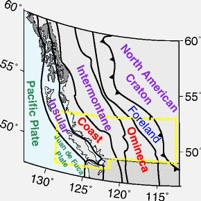
The Canadian Cordillera is part of one of the great mountain
systems on Earth. The geological and geophysical studies in southwestern
Canada have established that the lithosphere of the Cordillera
has evolved through episodes of rifting, seafloor spreading,
and plate separation, followed by subduction, ocean basin closing
and plate accretion. The concept of accretion of far-travelled
crustal blocks (terranes) that comprise plate fragments, island
arcs or microcontinents, was developed partly in the Canadian
Cordillera and is now used to interpret geological relationships
observed in many other orogens of the world.
The stages in the formation of the Cordilleran continental
crust can be summarized as follows:
- Development of a west-facing
passive margin along the western edge of North America
began about 1600 million years ago and
lasted through much of the Paleozoic. Rifting at about
750 Ma and breakup of the continent well before 540 Ma produced
an ancient ocean basin to the west.
- During the late Devonian
(about 370 Ma), an orogenic event produced volcanism
and plutonism west fothe miogeocline and
minor contractional folding and faulting of the shelf strata.
 Convergence
of North America with the composite oceanic basin caused
some terranes in the basin to amalgamate with one another
offshore, and thence for the amalgamated terranes to
converge with western North America. As terranes accreted
to North
America, the mountains were thrust upward and the continental
area expanded
westward. The accretion of the Intermontane superterrane
(180 Ma) initiated North American Cordilleran development,
resulting
in the formation of the Rocky Mountains/Foreland Belt
and the Omineca Belt, a plutonic, metamorphic suture zone
(Monger
et
al., 1982). Easterly convergence was accommodated by
oblique crustal shortening, strike-slip faulting and plutonism.
Between
100 and 40 Ma, large right-lateral strike-slip faults
formed in the western part of the Cordillera and accommodated
northward
motion of the terranes relative to North America. During
the mid-Cretaceous, the Insular superterrane was accreted,
forming
the Coast Belt as the suture with the Intermontaine superterrane.
The current locus of convergence is currently west of
Vancouver Island where the Juan de Fuca plate is subducting
beneath
North America. Convergence
of North America with the composite oceanic basin caused
some terranes in the basin to amalgamate with one another
offshore, and thence for the amalgamated terranes to
converge with western North America. As terranes accreted
to North
America, the mountains were thrust upward and the continental
area expanded
westward. The accretion of the Intermontane superterrane
(180 Ma) initiated North American Cordilleran development,
resulting
in the formation of the Rocky Mountains/Foreland Belt
and the Omineca Belt, a plutonic, metamorphic suture zone
(Monger
et
al., 1982). Easterly convergence was accommodated by
oblique crustal shortening, strike-slip faulting and plutonism.
Between
100 and 40 Ma, large right-lateral strike-slip faults
formed in the western part of the Cordillera and accommodated
northward
motion of the terranes relative to North America. During
the mid-Cretaceous, the Insular superterrane was accreted,
forming
the Coast Belt as the suture with the Intermontaine superterrane.
The current locus of convergence is currently west of
Vancouver Island where the Juan de Fuca plate is subducting
beneath
North America.- At 58 Ma, tectonism in the southern Canadian
Cordillera underwent a fundamental transition from east-west
shortening and crustal
thickening to large-scale east-west crustal stretching
and thinning along with continuing strike-slip deformation
farther
west.
- Since the major extensional episode during the early
Tertiary, the interior of the Cordillera has been relatively
quiescent,
while the western margin has undergone subduction-related
magmatism. East-dipping subduction continues today off
the west coast.
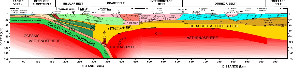
The Southern Cordillera Transect is investigating the nature,
structure, timing and dynamic evoilution of the Cordillera
from Vancouver Island to the Rocky Mountains.
LITHOPROBE Southern Cordillera Transect Objectives:
- to determine the structural and lithological relationships
between the accreted terranes and ancient North American
crust;
- to determine the geometric and geologic interrelationships
between terranes;
- to determine the crustal characteristics of the early
Tertiary extension and their relationships to previous contractional
structures;
- to define the depth and configuration of the Moho, or
the base of the crust, and indirectly its age;
- to outline the deep structure and subsurface geometry
of strike-slip faults;
- to determine the deep structure of the Coast Belt
and its relationship to ongoing subduction.
|